
-
Federal
National Agriculture Imagery Program (NAIP)
National Aeronautics and Space Administration —
The National Agriculture Imagery Program (NAIP) acquires aerial imagery during the agricultural growing seasons in the continental U.S. A primary goal of the NAIP... -
Federal
Global Pesticide Grids (PEST-CHEMGRIDS), Version 1.01
National Aeronautics and Space Administration —
The Global Pesticide Grids (PEST-CHEMGRIDS), Version 1.01 data set contains 20 of the most-used pesticide active ingredients on 6 dominant crops and 4 aggregated crop... -
Federal
Global Change Master Directory (GCMD)
National Aeronautics and Space Administration —
The GCMD database holds more than 30,000 descriptions of Earth science data sets and services covering all aspects of Earth and environmental sciences. The mission of... -
Federal
USGS High Resolution Orthoimagery
National Aeronautics and Space Administration —
High resolution orthorectified images combine the image characteristics of an aerial photograph with the geometric qualities of a map. An orthoimage is a uniform-... -
Federal
Global Fertilizer and Manure, Version 1: Nitrogen in Manure Production
National Aeronautics and Space Administration —
The Nitrogen in Manure Production data set of the Global Fertilizer and Manure, Version 1 Data Collection represents the amount of nitrogen manure produced and... -
Federal
Global Fertilizer and Manure, Version 1: Nitrogen Fertilizer Application
National Aeronautics and Space Administration —
The Nitrogen Fertilizer Application data set of the Global Fertilizer and Manure, Version 1 Data Collection represents the amount of nitrogen fertilizer nutrients... -
Federal
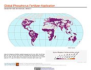
Global Fertilizer and Manure, Version 1: Phosphorus Fertilizer Application
National Aeronautics and Space Administration —
The Phosphorus Fertilizer Application data set of the Global Fertilizer and Manure, Version 1 Data Collection represents the amount of phosphorus fertilizer nutrients... -
Federal
SENTINEL-1A_SLC
National Aeronautics and Space Administration —
Sentinel-1A slant-range product -
Federal
SMAPVEX16 Manitoba PALS Brightness Temperature and Soil Moisture Data V001
National Aeronautics and Space Administration —
This product contains data derived from permanent in situ soil stations and observations by the Passive Active L-band System (PALS) microwave aircraft instrument. The... -
Federal
SENTINEL-1B_METADATA_SLC
National Aeronautics and Space Administration —
Metadata for Sentinel-1B slant-range product -
Federal
USGS JECAM Canada South Nation
National Aeronautics and Space Administration —
Joint Experiment for Crop Assessment and Monitoring The overarching goal of JECAM is to reach a convergence of approaches, develop monitoring and reporting protocols... -
Federal
Aquarius L2 Swath Single Orbit Soil Moisture V005
National Aeronautics and Space Administration —
This data set contains Level-2 global soil moisture estimates derived from the NASA Aquarius passive microwave radiometer on the Satélite de Aplicaciones Científicas... -
Federal
USGS Group on Earth Observations (GEO) Global Agricultural Monitoring (GLAM) Ukraine
National Aeronautics and Space Administration —
The objective of GEO is to fulfill a vision of a world where decisions and actions are informed by coordinated, comprehensive and sustained Earth Observation (EO).... -
Federal
USGS Global Forest Observations Initiative (GFOI) Brazil
National Aeronautics and Space Administration —
The Global Forest Observations Initiative (GFOI) is an initiative of the inter-governmental Group on Earth Observations (GEO) that aims to: foster the sustained... -
Federal
ERS-1_LEVEL1
National Aeronautics and Space Administration —
ERS-1 Standard Beam Data Level 1 -
Federal
Global Forest Observations Initiative (GFOI) - Fiji
National Aeronautics and Space Administration —
The Global Forest Observations Initiative (GFOI) is an initiative of the inter-governmental Group on Earth Observations (GEO) that aims to: foster the sustained... -
Federal
USGS Global Forest Observations Initiative (GFOI) Guyana
National Aeronautics and Space Administration —
The Global Forest Observations Initiative (GFOI) is an initiative of the inter-governmental Group on Earth Observations (GEO) that aims to: foster the sustained...

Official websites use .gov
A
.gov website belongs to an official government
organization in the United States.
Secure .gov websites use HTTPS
A
lock (
) or https:// means you’ve safely connected to
the .gov website. Share sensitive information only on official,
secure websites.