

191 datasets found
-
Federal
Frontier and Remote Area Codes
Department of Agriculture —
Frontier and Remote Area (FAR) codes provide a statistically-based, nationally-consistent, and adjustable definition of territory in the U.S. characterized by low... -
City
Traffic Signals
City of Bloomington —
This map data layer contains intersection points with traffic signals inside the City of Bloomington, Indiana. It is a subset of the Intersections data set. It also... -
City
Zoning & Overlay Districts
City of Somerville —
Polygon feature class representing the City of Somerville, Massachusetts zoning map adopted December 12, 2019 as part of the City of Somerville Zoning Overhaul... -
Federal
Foreclosure and Crime data for the District of Columbia and Miami-Dade County, Florida, 2003-2011
Department of Justice —
These data are part of NACJD's Fast Track Release and are distributed as they there received from the data depositor. The files have been zipped by NACJD for release,... -
City
Waterbodies
City of Bloomington —
This map data layer represents the linear hydrology features for the City of Bloomington, Indiana. This includes creeks, streams, lake shorelines, open channels, and... -
City
Bloomington City & Street Map Gallery
City of Bloomington —
Collection of static general Bloomington and city street maps of various sizes. -
Federal
GIBS Web Map Tile Service (WMTS)
National Aeronautics and Space Administration —
The WMTS implementation standard provides a standards-based solution for serviing digital maps using predefined image tiles. Through the constructs of the... -
City
Fire Stations
City of Bloomington —
Fire station locations throughout Monroe County, Indiana. This dataset is maintained by the Bloomington GIS department. -
County
King County GIS - Open Data site and FTP Download portal
King County, Washington —
King County GIS data is at: https://gis-kingcounty.opendata.arcgis.com/ (new KCGIS Open Data site) OR http://www5.kingcounty.gov/gisdataportal/ (legacy KCGIS data FTP... -
Federal
Landsat 2000
National Aeronautics and Space Administration —
Landsat.org, an affiliate of the Tropical Rain Forest Information Center (TRFIC), now hosts the Global Orthorectified Landsat Datasets for four epochs: 1970's MSS,... -
Federal
HHS COVID-19 Small Area Estimations Survey - Primary Vaccine Series - Wave 09
U.S. Department of Health & Human Services —
The goal of the Monthly Outcome Survey (MOS) Small Area Estimations (SAE) is to generate estimates of the proportions of adults, by county and month, who were in the... -
City
City Limits
City of Somerville —
ESRI polygon feature class representing the City of Somerville, Massachusetts city boundary. -
Federal
HHS COVID-19 Small Area Estimations Survey - Primary Vaccine Series - Wave 28
U.S. Department of Health & Human Services —
The goal of the Monthly Outcome Survey (MOS) Small Area Estimations (SAE) is to generate estimates of the proportions of adults, by county and month, who were in the... -
City
City Maintained Streets
City of Bloomington —
This map data layer represents the centerline of roadways for the City of Bloomington, Indiana. It includes source data from the City of Bloomington and Monroe... -
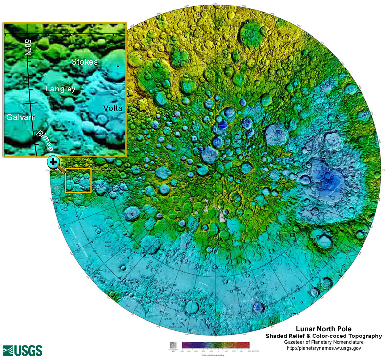
Federal
Gazetteer of Planetary Nomenclature: Moon: 1:10 million-scale Shaded Relief and Color-coded Topography: North Pole
National Aeronautics and Space Administration —
These lunar maps display the four different areas of the moon with color-coded topography in low and high resolution approved by the International Astronomical Union... -
City
Fiber and Communications Map Gallery
City of Bloomington —
Maps depicting the public Bloomington fiber and communications geospatial data. -
Federal
PDS Planetary Maps API
National Aeronautics and Space Administration —
We are developing a set of NASA Extensions to the Google Maps API—and soon to other frameworks such as OpenLayers as well—that will make these platforms more useful... -
City
Bloomington 2-Mile Fringe
City of Bloomington —
This map data layer represents the former 2 Mile Fringe for the City of Bloomington, Indiana. This area was establish by an inter-local agreement between the City of... -
Federal
HHS COVID-19 Small Area Estimations Survey - Primary Vaccine Series - Wave 18
U.S. Department of Health & Human Services —
The goal of the Monthly Outcome Survey (MOS) Small Area Estimations (SAE) is to generate estimates of the proportions of adults, by county and month, who were in the...
191 datasets found