
-
Federal
National Coral Reef Monitoring Program: Benthic cover derived from analysis of images collected from climate stations across the Pacific Remote Island Areas
National Oceanic and Atmospheric Administration, Department of Commerce —
The benthic cover data in this collection result from analyzing the images produced from ongoing National Coral Reef Monitoring Program (NCRMP) benthic photo-quadrat... -
Federal
Benthic Surveys in Faga'alu, American Samoa: benthic cover derived from analysis of benthic images collected during belt transect surveys of coral demography in 2015 and 2020
National Oceanic and Atmospheric Administration, Department of Commerce —
The benthic cover data described herein were generated by the NOAA Ecosystem Sciences Division (former Coral Reef Ecosystem Program, CREP) from the quantitative... -
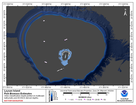
Federal
CRED Fish Biomass Estimates map at Laysan Island
National Oceanic and Atmospheric Administration, Department of Commerce —
This map displays fish biomass observation locations overlaid on bathymetry -
Federal
Carbonate budget methods comparison at Cheeca Rocks (Florida, USA) (NCEI Accession 0305035)
National Oceanic and Atmospheric Administration, Department of Commerce —
Carbonate budget assessments quantify changes to reef habitat structure by measuring the cover of habitat altering taxa (calcifies and eroders) and assimilating... -
Federal
CRED Optical Validation Data at the island of Ofu and Olosega in American Samoa, 2012 to support Benthic Habitat Mapping (TOAD)
National Oceanic and Atmospheric Administration, Department of Commerce —
Optical validation data were collected using the Tethered Optical Assessment Device (TOAD), a sled equipped with underwater video camera, still camera and lights.... -
Federal
1988 Mosaic of Aerial Photography of the Salt River Bay National Historical Park and Ecological Preserve
National Oceanic and Atmospheric Administration, Department of Commerce —
Aerial photographs taken by NOAA's National Geodetic Survey during 1988 were mosaicked and orthorectified by the Biogeography Branch. The resulting image was used to... -
Federal
National Coral Reef Monitoring Program: Orthorectified mosaic images of a coral reef in Flower Garden Banks National Marine Sanctuary collected on 2019-06-03 and 2019-06-04 (NCEI Accession 0223261)
National Oceanic and Atmospheric Administration, Department of Commerce —
This data set contains landscape mosaic images, created as a product for the NOAA Coral Reef Conservation Programâs (CRCP) National Coral Reef Monitoring Program... -
Federal
CRED Optical Validation Data at the island of Ofu and Olosega in American Samoa, 2006 to support Benthic Habitat Mapping (TOAD)
National Oceanic and Atmospheric Administration, Department of Commerce —
Optical validation data were collected using a Tethered Optical Assessment Device (TOAD), an underwater sled equipped with an underwater digital video camera and... -
Federal
A synthesis of benthic percent cover data in the Mariana Islands Archipelago covering a period of 22 years (2000-2022) and summarized at three spatial scales (archipelago-, island-, and sub-island-scales) (NCEI Accession 0299811)
National Oceanic and Atmospheric Administration, Department of Commerce —
The benthic percent cover data described in this record is a result of a synthesizing effort led by the Ecosystem Sciences Division (ESD) to integrate benthic cover... -
Federal
National Coral Reef Monitoring Program: Benthic cover derived from analysis of images collected from climate stations across the Mariana Archipelago
National Oceanic and Atmospheric Administration, Department of Commerce —
The benthic cover data in this collection result from the analysis of images produced during benthic photo-quadrat surveys conducted along transects at climate... -
Federal
National Coral Reef Monitoring Program: Orthorectified mosaic images of a coral reef in Brewers Bay, St. Thomas USVI collected on 2023-07-26 (NCEI Accession 0300357)
National Oceanic and Atmospheric Administration, Department of Commerce —
This data set contains landscape mosaic images, created as a product for the NOAA Coral Reef Conservation Programâs (CRCP) National Coral Reef Monitoring Program... -
Federal
National Coral Reef Monitoring Program: Benthic Cover Derived from Analysis of Benthic Images Collected during Stratified Random Surveys (StRS) across American Samoa in 2015, 2018, and 2023.
National Oceanic and Atmospheric Administration, Department of Commerce —
The data described here result from benthic photo-quadrat surveys conducted along transects at stratified random sites across the American Samoa in 2015, 2018, and... -
Federal
Identifying coral reef resilience potential in Tutuila, American Samoa based on NOAA coral reef monitoring data from 2010 to 2016
National Oceanic and Atmospheric Administration, Department of Commerce —
Declines in the health of coral reef ecosystems lead scientists to search for factors that support reef resilience: the ability of reefs to resist environmental... -
Federal
Reefs for the future: Resilience of coral reefs in the main Hawaiian Islands
National Oceanic and Atmospheric Administration, Department of Commerce —
Declining health of coral reef ecosystems led scientists to search for factors that support reef resilience: the ability of reefs to resist and recover from... -
Federal
CRED Fish Biomass Estimates map at French Frigate Shoals, 2001-2008
National Oceanic and Atmospheric Administration, Department of Commerce —
This map displays fish biomass observation locations overlaid on bathymetry -
Federal
CRED Fish Biomass Estimates map at Pearl and Hermes Atoll.
National Oceanic and Atmospheric Administration, Department of Commerce —
This map displays fish biomass observation locations overlaid on bathymetry. -
Federal
CRED Optical Validation Data at the island of Ta'u in American Samoa, 2006 to support Benthic Habitat Mapping (TOAD)
National Oceanic and Atmospheric Administration, Department of Commerce —
Optical validation data were collected using a Tethered Optical Assessment Device (TOAD), an underwater sled equipped with an underwater digital video camera and... -
Federal
CRED Optical Validation Data at the island of Ta'u in American Samoa, 2012 to support Benthic Habitat Mapping (TOAD)
National Oceanic and Atmospheric Administration, Department of Commerce —
Optical validation data were collected using the Tethered Optical Assessment Device (TOAD), a sled equipped with underwater video camera, still camera and lights.... -
Federal
Baseline characterization of benthic and coral communities of the Flower Garden Banks (2010 - 2012) (NODC Accession 0124257)
National Oceanic and Atmospheric Administration, Department of Commerce —
This study utilized ROV photograph transects to quantify benthic habitat and coral communities among the five habitat types (algal nodule, coralline algal reefs, deep... -
Federal
1992 Mosaic of Aerial Photography of the Salt River Bay National Historical Park and Ecological Preserve
National Oceanic and Atmospheric Administration, Department of Commerce —
Aerial photographs taken by NOAA's National Geodetic Survey during 1992 were mosaicked and orthorectified by the Biogeography Branch. The resulting image was used to...

Official websites use .gov
A
.gov website belongs to an official government
organization in the United States.
Secure .gov websites use HTTPS
A
lock (
) or https:// means you’ve safely connected to
the .gov website. Share sensitive information only on official,
secure websites.