

12 datasets found
-
Federal
GPM GROUND VALIDATION DC-8 CAMERA NADIR GCPEX V1
National Aeronautics and Space Administration —
The GPM Ground Validation DC-8 Camera Nadir GCPEx dataset contains geo-located, visible-wavelength imagery of the ground obtained from the nadir camera aboard the... -
Federal
JPSS-2 CrIS IMG_COL: Array indices for collocated VIIRS observations V3.0 (SNDRJ2CrISL1BIMGC) at GES DISC
National Aeronautics and Space Administration —
The Cross-track Infrared Sounder (CrIS) Level 1B Full Spectral Resolution (FSR) data files contain radiance measurements along with ancillary spacecraft, instrument,... -
Federal
MODIS/Aqua Calibrated Radiances 250m 5-Min L1B Narrow Swath Subset along CloudSat V002 (MAC02QS0) at GES DISC NGDA
National Aeronautics and Space Administration —
This is the narrow-swath MODIS/Aqua subset along CloudSat field of view track. The goal of the narrow-swath subset is to select and return MODIS data that are within... -
Federal
TRMM Microwave Imager Calibrated Radiances L1B 1.5 hours V7 (TRMM_1B11) at GES DISC
National Aeronautics and Space Administration —
This dataset contains TRMM Micrwave Imager (TMI) L1B calibrated radiances in terms of Brightness Temperatures. The TMI calibration algorithm (1B11) converts the... -
Federal
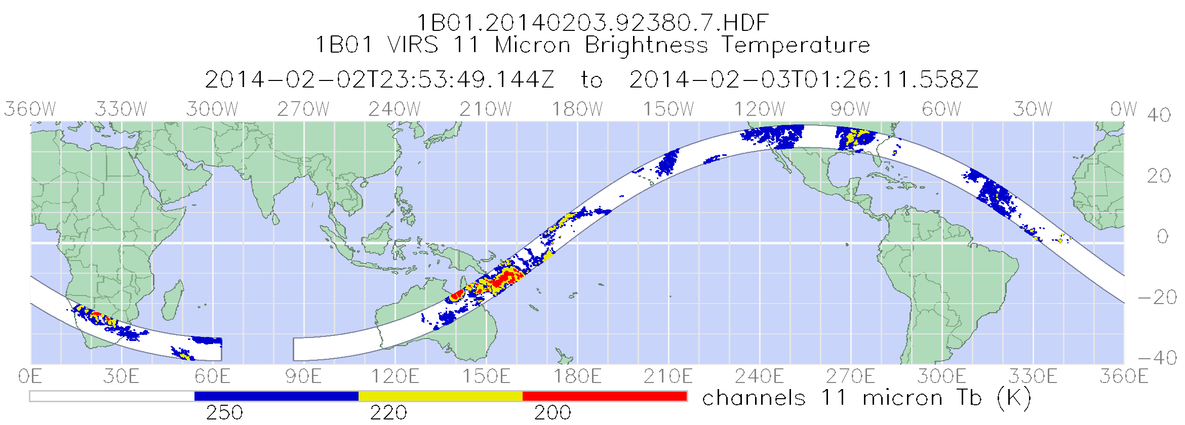
TRMM Visible and Infrared Scanner Calibrated Radiances L1B 1.5 hours V7 (TRMM_1B01) at GES DISC
National Aeronautics and Space Administration —
This TRMM Visible and Infrared Scanner (VIRS) Level 1B Calibrated Radiance Product (1B01) contains calibrated radiances and auxiliary geolocation information from the... -
Federal
TRMM Attitude and VIRS Packets and Header Record L1A V7 (TRMM_1A01) at GES DISC
National Aeronautics and Space Administration —
The Level-1A Product file, "1A01", is a concatenation of Header record, Spacecraft Attitude packets, VIRS Housekeeping Data packets, VIRS Science Data packets, QACs,... -
Federal
JPSS-2 CrIS IMG: Collocated VIIRS level 1 / cloud mask statistical summary V3.0 (SNDRJ2CrISL1BIMG) at GES DISC
National Aeronautics and Space Administration —
The Cross-track Infrared Sounder (CrIS) Level 1B Full Spectral Resolution (FSR) data files contain radiance measurements along with ancillary spacecraft, instrument,... -
Federal
TRMM Attitude and TMI Packets and Header Record L1A V7 (TRMM_1A11) at GES DISC
National Aeronautics and Space Administration —
The Level-1A Product file, "1A11", is a concatenation of Header record, Spacecraft Attitude packets, TMI Housekeeping packets, TMI Science Data packets, QACs and an... -
Federal
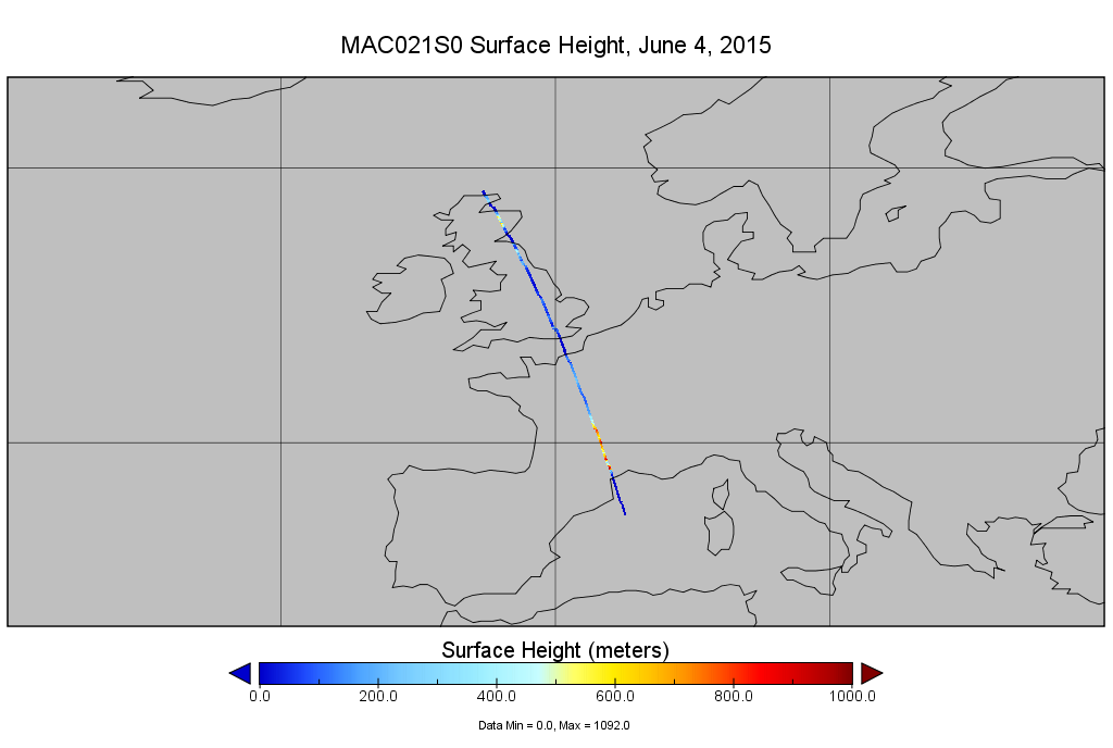
MODIS/Aqua Calibrated Radiances 1km 5-Min 1B Narrow Swath Subset along CloudSat V002 (MAC021S0) at GES DISC NGDA
National Aeronautics and Space Administration —
This is the narrow-swath MODIS/Aqua subset along CloudSat field of view track. The goal of the narrow-swath subset is to select and return MODIS data that are within... -
Federal
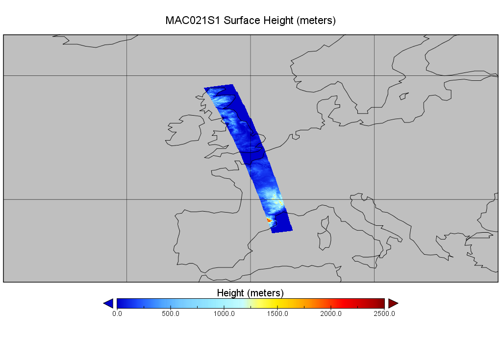
MODIS/Aqua Calibrated Radiances 1km 5-Min 1B Wide Swath Subset along CloudSat V002 (MAC021S1) at GES DISC NGDA
National Aeronautics and Space Administration —
This is the wide-swath MODIS/Aqua subset along CloudSat field of view track. The goal of the wide-swath subset is to select and return MODIS data that are within... -
Federal
ABoVE LVIS L1A Geotagged Images V001
National Aeronautics and Space Administration —
This data set contains geotagged images collected over Alaska and Western Canada. The images were taken by the NASA Digital Mapping Camera, paired with the Land,... -
Federal
MODIS/Aqua Calibrated Radiances 250m 5-Min L1B Wide Swath Subset along CloudSat V002 (MAC02QS1) at GES DISC NGDA
National Aeronautics and Space Administration —
This is the wide-swath MODIS/Aqua subset along CloudSat field of view track. The goal of the wide-swath subset is to select and return MODIS data that are within...
12 datasets found