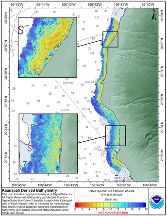
Derived bathymetry from IKONOS satellite imagery of nearshore benthic habitats
Access & Use Information
Downloads & Resources
-
ftp://ftp.soest.hawaii.edu/pibhmc/website/data/...ZIP
DD2_Depth2_filtermin4x4_10m.zip
-
Full Metadata Record
View the complete metadata record on InPort for more information about this...
-
Pacific Islands Fisheries Science Center Website
Pacific Island Fisheries Science Center homepage
-
Citation URLHTML
Online Resource
-
GCMD Keyword Forum Page
Global Change Master Directory (GCMD). 2024. GCMD Keywords, Version 19....
-
NOAA Data Management Plan (DMP)PDF
NOAA Data Management Plan for this record on InPort.
Dates
| Metadata Date | February 29, 2024 |
|---|---|
| Metadata Created Date | October 19, 2024 |
| Metadata Updated Date | October 19, 2024 |
| Reference Date(s) | 2016 (publication) |
| Frequency Of Update | notPlanned |
Metadata Source
- ISO-19139 ISO-19139 Metadata
Harvested from NMFS PIFSC
Graphic Preview

Additional Metadata
| Resource Type | Dataset |
|---|---|
| Metadata Date | February 29, 2024 |
| Metadata Created Date | October 19, 2024 |
| Metadata Updated Date | October 19, 2024 |
| Reference Date(s) | 2016 (publication) |
| Responsible Party | (Point of Contact, Custodian) |
| Contact Email | |
| Guid | gov.noaa.nmfs.inport:25280 |
| Access Constraints | Cite As: Pacific Islands Fisheries Science Center, [Date of Access]: Derived bathymetry from IKONOS satellite imagery of nearshore benthic habitats [Data Date Range], https://www.fisheries.noaa.gov/inport/item/25280., Access Constraints: none, Use Constraints: These data are not to be used for navigation purposes. Please acknowledge the NOAA Pacific Islands Fisheries Science Center, and the Joint Institute for Marine and Atmospheric Research (JIMAR) and Hawaii Mapping Research Group (HMRG) at the University of Hawaii as the sources of this information., Distribution Liability: These data are not to be used for navigational purposes. NOAA makes no warranty regarding these data, expressed or implied, nor does the fact of distribution constitute such a warranty. NOAA cannot assume liability for any damages caused by any errors or omissions in these data, nor as a result of the failure of these data to function on a particular system. |
| Bbox East Long | -156.647 |
| Bbox North Lat | 20.9839 |
| Bbox South Lat | 20.8357 |
| Bbox West Long | -156.776 |
| Coupled Resource | |
| Frequency Of Update | notPlanned |
| Graphic Preview Description | Layout of data on original satellite imagery |
| Graphic Preview File | http://www.soest.hawaii.edu/pibhmc/MHI_images/KaanapaliDerivedBathy_445.jpg |
| Graphic Preview Type | JPEG |
| Harvest Object Id | 54388ec4-30f6-473a-becf-92104e5fd1d6 |
| Harvest Source Id | c0beac72-5f43-4455-8c33-1b345fbc2dfe |
| Harvest Source Title | NMFS PIFSC |
| Licence | NOAA provides no warranty, nor accepts any liability occurring from any incomplete, incorrect, or misleading data, or from any incorrect, incomplete, or misleading use of the data. It is the responsibility of the user to determine whether or not the data is suitable for the intended purpose. |
| Lineage | |
| Metadata Language | eng |
| Metadata Type | geospatial |
| Old Spatial | {"type": "Polygon", "coordinates": [[[-156.776, 20.8357], [-156.647, 20.8357], [-156.647, 20.9839], [-156.776, 20.9839], [-156.776, 20.8357]]]} |
| Progress | completed |
| Spatial Data Service Type | |
| Spatial Reference System | |
| Spatial Harvester | True |
| Temporal Extent Begin | 2010-04-06 |
| Temporal Extent End | 2010-04-06 |
Didn't find what you're looking for? Suggest a dataset here.

