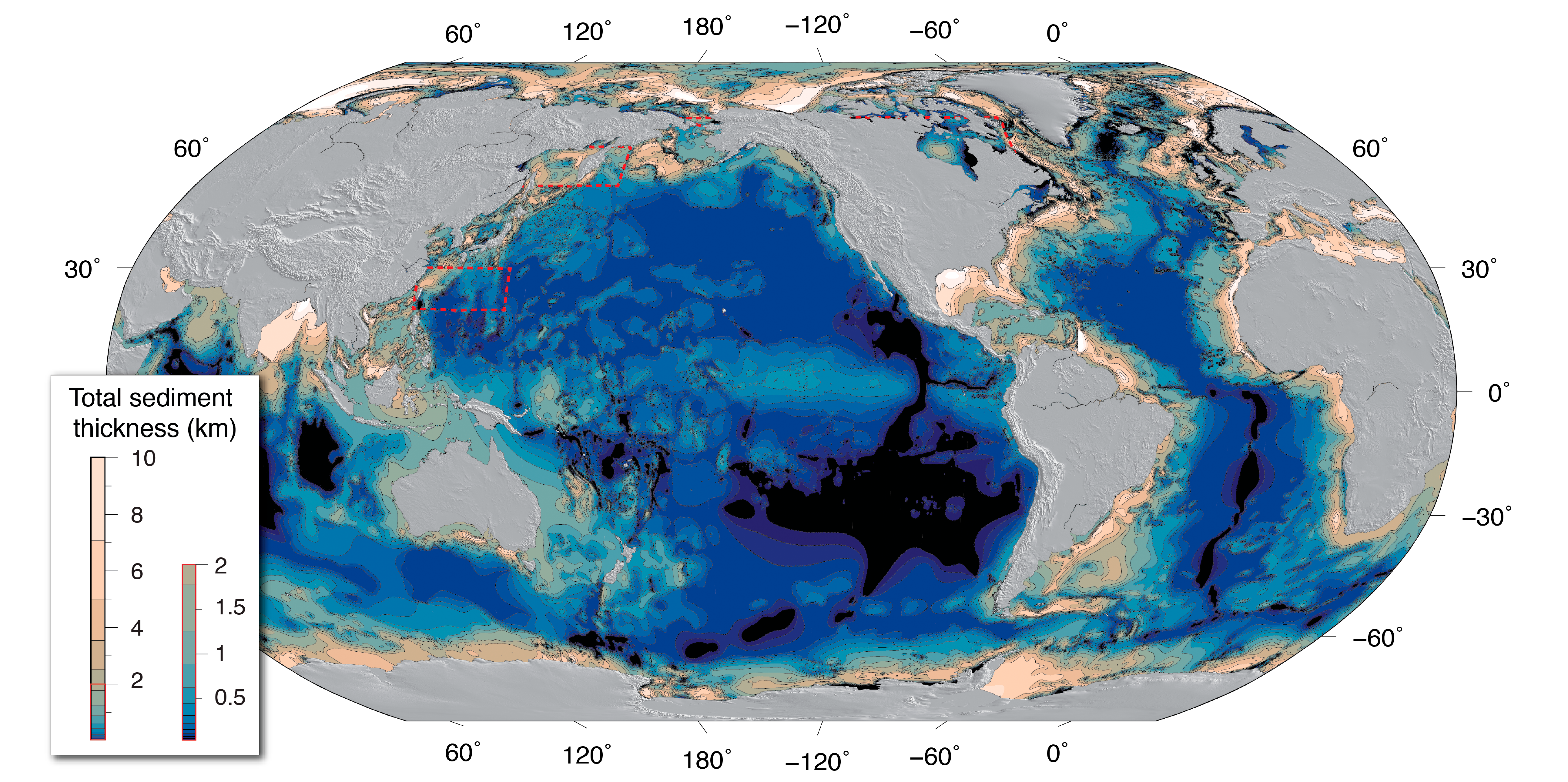
GlobSed: Updated Total Sediment Thickness in the World's Oceans
Access & Use Information
Downloads & Resources
-
GMT NetCDF grd file
GMT NetCDF grd file
-
ArcGIS
ArcGIS
-
ASCII xyz
ASCII xyz
-
GlobSed: Updated Total Sediment Thickness in...
web access to GlobSed: Updated Total Sediment Thickness in the World's...
-
GCMD Keyword Forum Page
Global Change Master Directory (GCMD). 2024. GCMD Keywords, Version 19....
-
GCMD Keyword Forum Page
Global Change Master Directory (GCMD). 2024. GCMD Keywords, Version 19....
-
GCMD Keyword Forum Page
Global Change Master Directory (GCMD). 2024. GCMD Keywords, Version 19....
-
Geochemistry, Geophysics, Geosystems
Journal article describing the Global sediment thickness dataset updated for...
Dates
| Metadata Date | June 24, 2025 |
|---|---|
| Metadata Created Date | October 18, 2024 |
| Metadata Updated Date | June 28, 2025 |
| Reference Date(s) | March 1, 2019 (publication) |
| Frequency Of Update | asNeeded |
Metadata Source
- ISO-19139 ISO-19139 Metadata
Harvested from NGDC MGG Geophysics
Graphic Preview

Additional Metadata
| Resource Type | Dataset |
|---|---|
| Metadata Date | June 24, 2025 |
| Metadata Created Date | October 18, 2024 |
| Metadata Updated Date | June 28, 2025 |
| Reference Date(s) | March 1, 2019 (publication) |
| Responsible Party | The Centre for Earth Evolution and Dynamics (CEED), University of Oslo, Norway (Point of Contact) |
| Contact Email | |
| Guid | gov.noaa.ngdc.mgg.geophysics:G01065_v3 |
| Access Constraints | Distribution liability: NOAA and NCEI make no warranty, expressed or implied, regarding these data, nor does the fact of distribution constitute such a warranty. NOAA and NCEI cannot assume liability for any damages caused by any errors or omissions in these data. If appropriate, NCEI can only certify that the data it distributes are an authentic copy of the records that were accepted for inclusion in the NCEI archives., Use Constraints: None, Access Constraints: None |
| Bbox East Long | 180 |
| Bbox North Lat | 90.0000 |
| Bbox South Lat | -90 |
| Bbox West Long | -180 |
| Coupled Resource | |
| Frequency Of Update | asNeeded |
| Graphic Preview Description | Image of total sediment thickness of the world's oceans and marginal seas, Version 3 |
| Graphic Preview File | https://www.ngdc.noaa.gov/mgg/sedthick/data/version3/fig_2_new_press.png |
| Graphic Preview Type | png |
| Harvest Object Id | b066ef14-0996-4761-9969-aabb181e17dc |
| Harvest Source Id | 80dfcf5d-5e08-457e-83e4-cfc696e378bc |
| Harvest Source Title | NGDC MGG Geophysics |
| Licence | |
| Lineage | |
| Metadata Language | eng; USA |
| Metadata Type | geospatial |
| Old Spatial | {"type": "Polygon", "coordinates": [[[-180.0, -90.0], [180.0, -90.0], [180.0, 90.0], [-180.0, 90.0], [-180.0, -90.0]]]} |
| Progress | |
| Spatial Data Service Type | |
| Spatial Reference System | |
| Spatial Harvester | True |
Didn't find what you're looking for? Suggest a dataset here.

