

Sentinel-5P TROPOMI Near-Real-Time (NRT) Radiance product band 3 (UVIS detector) L1B 5.5km x 3.5km V2 (S5P_L1B_RA_BD3_HiR_NRT) at GES DISC
Access & Use Information
Public: This dataset is intended for public access and use.
License: No license information was provided. If this work was prepared by an officer or employee of the United States government as part of that person's official duties it is considered a U.S. Government Work.
Downloads & Resources
-
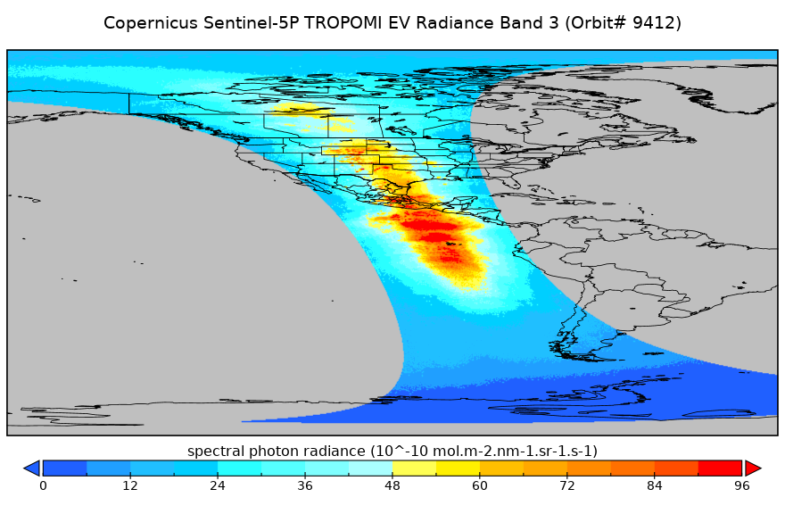
Get a related visualizationPNG
S5P_OFFL_L1B_RA_BD3_HiR_1.png
-
This dataset's landing pageHTML
Access the dataset landing page from the GES DISC website.
-
Use OPeNDAP to access the dataset's dataHTML
Access the data via the OPeNDAP protocol.
-
Download this dataset through a directory mapHTML
Access the data via HTTPS.
-
View this dataset's algorithm theoretical...HTML
Algorithm Theoretical Basis Document
-
View the primary investigator's documentation...HTML
Data Specification Document
-
Download this dataset through Earthdata SearchHTML
Use the Earthdata Search to find and retrieve data sets across multiple data...
-
View this dataset's read me documentHTML
README Document
-
The dataset's project home pageHTML
ESA Copernicus Sentinal 5P Home Page
-
View this dataset's product historyHTML
S5P TROPOMI Data Collection Summary
-
Landing PageLanding Page
Dates
| Metadata Created Date | March 4, 2025 |
|---|---|
| Metadata Updated Date | April 11, 2025 |
Metadata Source
- Data.json Data.json Metadata
Harvested from NASA Data.json
Additional Metadata
| Resource Type | Dataset |
|---|---|
| Metadata Created Date | March 4, 2025 |
| Metadata Updated Date | April 11, 2025 |
| Publisher | NASA/GSFC/SED/ESD/GCDC/GESDISC |
| Maintainer | |
| Identifier | C3412185365-GES_DISC |
| Data First Published | 2025-01-27 |
| Language | en-US |
| Data Last Modified | 2025-03-31 |
| Category | Sentinel-5P, geospatial |
| Public Access Level | public |
| Bureau Code | 026:00 |
| Metadata Context | https://project-open-data.cio.gov/v1.1/schema/catalog.jsonld |
| Schema Version | https://project-open-data.cio.gov/v1.1/schema |
| Catalog Describedby | https://project-open-data.cio.gov/v1.1/schema/catalog.json |
| Harvest Object Id | 290de8d1-eeae-45e9-88d3-8633b651957b |
| Harvest Source Id | 58f92550-7a01-4f00-b1b2-8dc953bd598f |
| Harvest Source Title | NASA Data.json |
| Homepage URL | https://cmr.earthdata.nasa.gov:443/search/concepts/C3412185365-GES_DISC.html |
| Metadata Type | geospatial |
| Old Spatial | -180.0 -90.0 180.0 90.0 |
| Program Code | 026:001 |
| Source Datajson Identifier | True |
| Source Hash | 37952aecddebc750ec2ac04b03d37183cb144057c27d0efb218c0aae4ee62c0b |
| Source Schema Version | 1.1 |
| Spatial | |
| Temporal | 2025-01-27T00:00:00Z/2025-03-03T00:00:00Z |
Didn't find what you're looking for? Suggest a dataset here.