

Tularosa Basin Play Fairway Analysis: Methodology Flow Charts
Access & Use Information
Public: This dataset is intended for public access and use.
License:
Creative Commons Attribution
Downloads & Resources
-
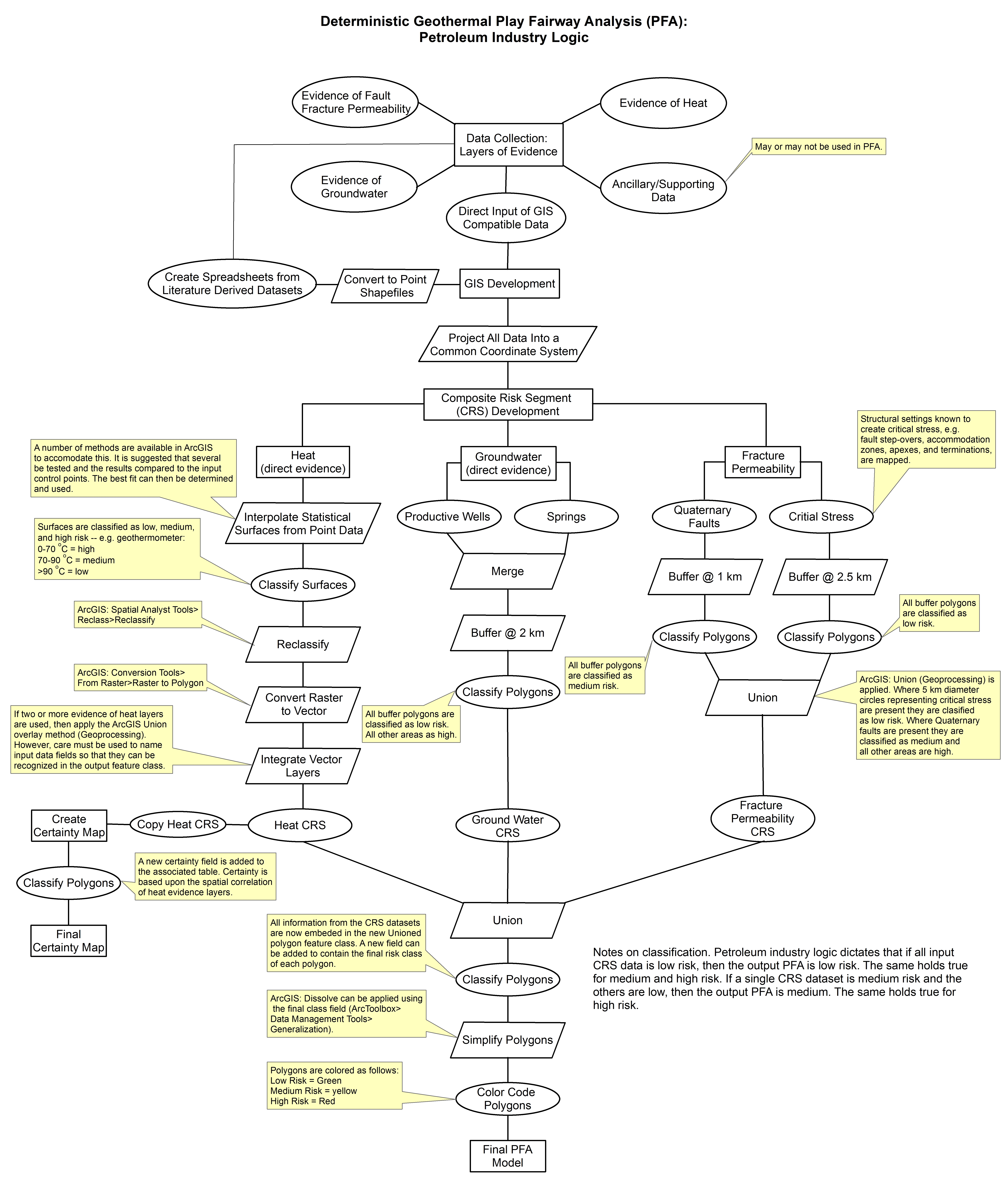
Deterministic PFA Methodology.jpgJPEG
Comprehensive methodology used in the creation of a Deterministic Geothermal...
-
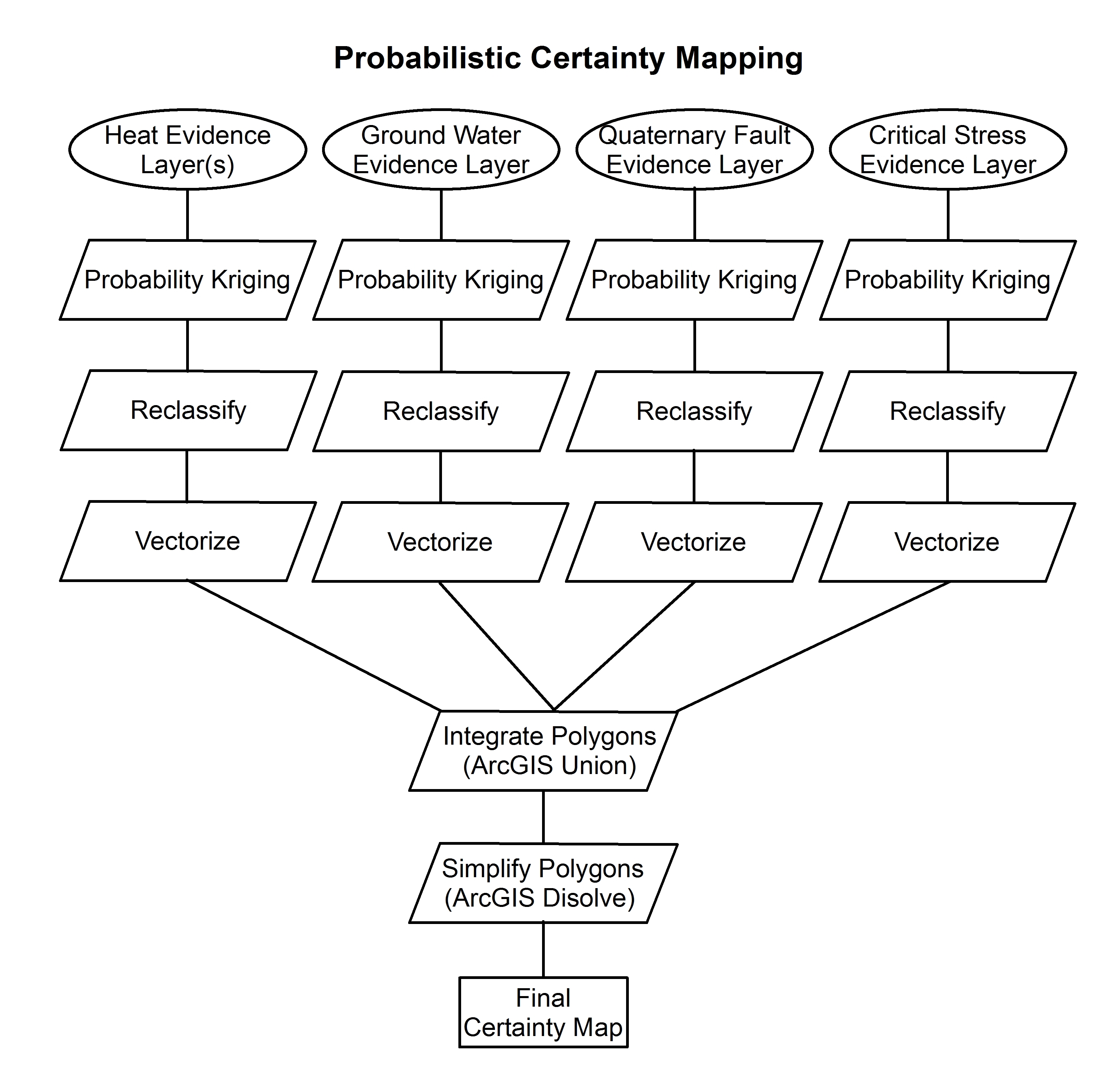
Certainty Methodology.jpgJPEG
Stochastic certainty maps are data-driven, leaving calculable error.....
-
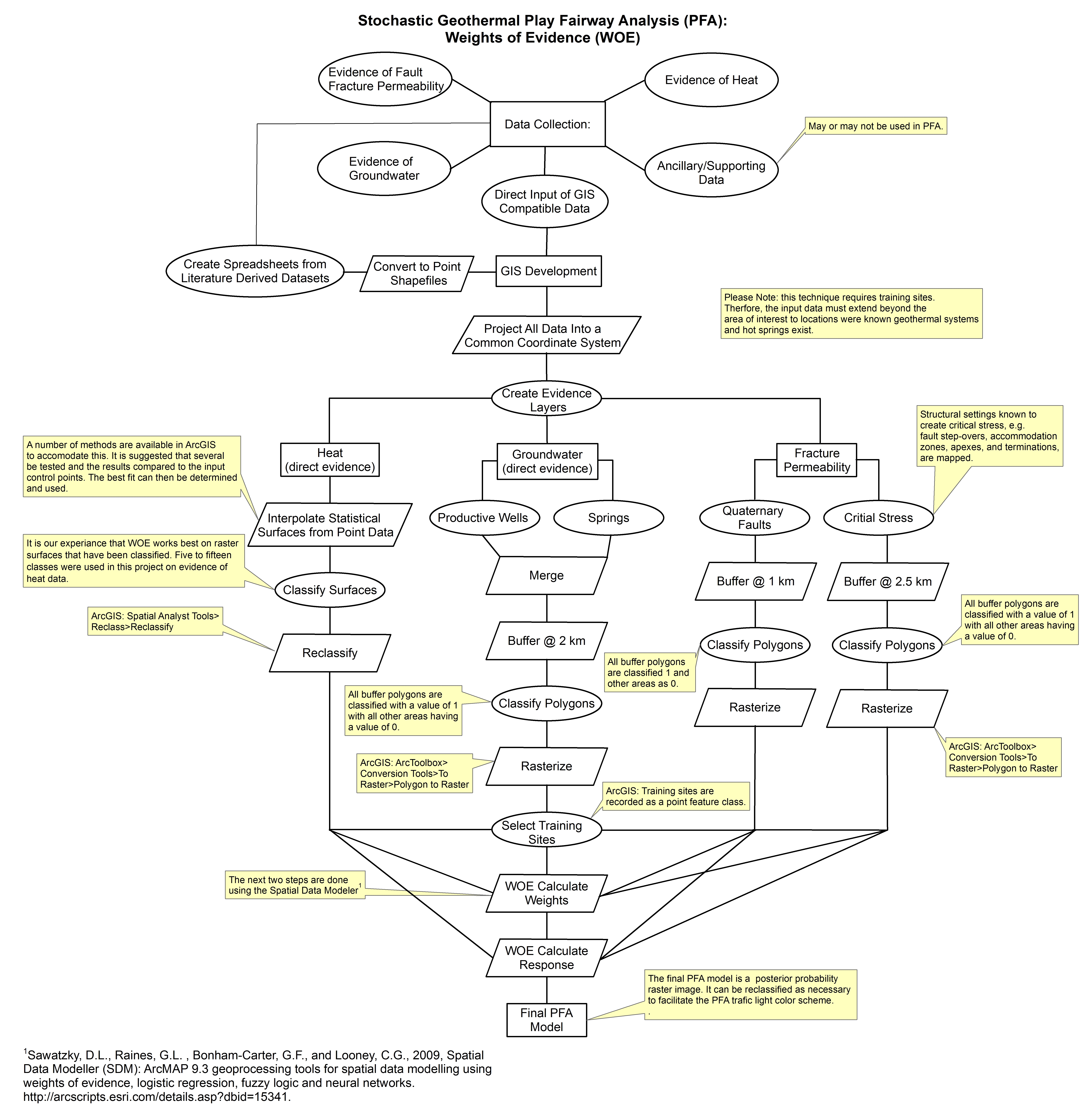
Weights of Evidence Methodology.jpgJPEG
This is the method for using weights of evidence to explore for geothermal...
-
Landing PageLanding Page
Dates
| Metadata Created Date | January 11, 2025 |
|---|---|
| Metadata Updated Date | January 20, 2025 |
Metadata Source
- Data.json Data.json Metadata
Harvested from OpenEI data.json
Additional Metadata
| Resource Type | Dataset |
|---|---|
| Metadata Created Date | January 11, 2025 |
| Metadata Updated Date | January 20, 2025 |
| Publisher | University of Utah |
| Maintainer | |
| Doi | 10.15121/1261944 |
| Identifier | https://data.openei.org/submissions/6870 |
| Data First Published | 2015-11-15T07:00:00Z |
| Data Last Modified | 2017-08-04T15:05:16Z |
| Public Access Level | public |
| Bureau Code | 019:20 |
| Metadata Context | https://openei.org/data.json |
| Metadata Catalog ID | https://openei.org/data.json |
| Schema Version | https://project-open-data.cio.gov/v1.1/schema |
| Catalog Describedby | https://project-open-data.cio.gov/v1.1/schema/catalog.json |
| Data Quality | True |
| Datagov Dedupe Retained | 20250120143002 |
| Harvest Object Id | 3d758406-3844-48e5-9249-2371e4386b0d |
| Harvest Source Id | 7cbf9085-0290-4e9f-bec1-91653baeddfd |
| Harvest Source Title | OpenEI data.json |
| Homepage URL | https://gdr.openei.org/submissions/625 |
| License | https://creativecommons.org/licenses/by/4.0/ |
| Old Spatial | {"type":"Polygon","coordinates":-106.80273970623,31.594120696413,-105.34385596666,31.594120696413,-105.34385596666,34.150049643381,-106.80273970623,34.150049643381,-106.80273970623,31.594120696413} |
| Program Code | 019:006 |
| Projectlead | Mike Weathers |
| Projectnumber | EE0006730 |
| Projecttitle | Innovative Play Fairway Modelling Applied to the Tularosa Basin |
| Source Datajson Identifier | True |
| Source Hash | eb945531b62627069c3b0b6d19ed331382853fd5b922ee8e38f084eaef47f307 |
| Source Schema Version | 1.1 |
| Spatial | {"type":"Polygon","coordinates":-106.80273970623,31.594120696413,-105.34385596666,31.594120696413,-105.34385596666,34.150049643381,-106.80273970623,34.150049643381,-106.80273970623,31.594120696413} |
Didn't find what you're looking for? Suggest a dataset here.