

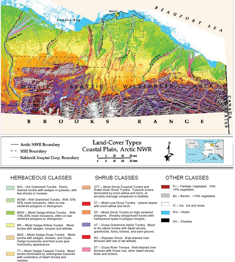
Land Cover and Vegetation Map, Arctic National Wildlife Refuge
Access & Use Information
Public: This dataset is intended for public access and use.
License: No license information was provided. If this work was prepared by an officer or employee of the United States government as part of that person's official duties it is considered a U.S. Government Work.
Downloads & Resources
-
Data Information (Unknown Format)BIN
-
Data Information (HTML)HTML
-
Data Information (ZIP)ZIP
Arctic_Wildlife_Refuge_Veg_Map_1384.zip
-
Data Information (PNG)PNG
Arctic_Wildlife_Refuge_Veg_Map_Fig1.png
-
Data Information (Unknown Format)BIN
-
Data Information (PDF)PDF
Arctic_Wildlife_Refuge_Veg_Map.pdf
-
Data Information (PDF)PDF
Jorgenson_1994_Arctic_National_Wildlife_Refuge.pdf
-
Landing PageLanding Page
Dates
| Metadata Created Date | April 11, 2025 |
|---|---|
| Metadata Updated Date | September 19, 2025 |
Metadata Source
- Data.json Data.json Metadata
Harvested from NASA Data.json
Additional Metadata
| Resource Type | Dataset |
|---|---|
| Metadata Created Date | April 11, 2025 |
| Metadata Updated Date | September 19, 2025 |
| Publisher | ORNL_DAAC |
| Maintainer | |
| Identifier | 10.3334/ORNLDAAC/1384 |
| Data Last Modified | 2025-09-11 |
| Category | Earth Science |
| Public Access Level | public |
| Bureau Code | 026:00 |
| Metadata Context | https://project-open-data.cio.gov/v1.1/schema/catalog.jsonld |
| Schema Version | https://project-open-data.cio.gov/v1.1/schema |
| Catalog Describedby | https://project-open-data.cio.gov/v1.1/schema/catalog.json |
| Harvest Object Id | 2270b41b-bb8a-477f-b997-c8ed5ef8b35c |
| Harvest Source Id | 58f92550-7a01-4f00-b1b2-8dc953bd598f |
| Harvest Source Title | NASA Data.json |
| Homepage URL | https://search.earthdata.nasa.gov/search?q=Arctic_Wildlife_Refuge_Veg_Map_1384&ac=true |
| Old Spatial | {"WestBoundingCoordinate":-147.051,"NorthBoundingCoordinate":70.7117,"EastBoundingCoordinate":-140.322,"SouthBoundingCoordinate":68.8981},"CARTESIAN" |
| Program Code | 026:000 |
| Source Datajson Identifier | True |
| Source Hash | b16da8a2c9dd2d6e262a03da3508ba43168a59fb577c72e01f62449a0a67d350 |
| Source Schema Version | 1.1 |
| Spatial | |
| Temporal | 1982-06-01/1982-06-01 |
Didn't find what you're looking for? Suggest a dataset here.