NOAA Monthly U.S. Climate Divisional Database (NClimDiv)
Access & Use Information
Downloads & Resources
-
NCEI Dataset Landing Page
Landing page for the dataset.
-
U.S. Climate Divisional Data Overview Page
Overview of the Climate Divisional Dataset
-
NCEI Direct Download (archive)
Direct download ___location for archive files
-
NCEI Direct Download (real-time)
Direct download ___location for real-time files
-
NCEI Direct Download (dataset documentation)
Direct download ___location for the documentation files
-
Climate Data Online Map for Climate Indices
View Divisional Climate Data and Products via a map interface
-
Climate at a Glance National Maps
Comparisons of meteorological local, state, regional, national, data in...
-
KMZ downloadKML
Direct download KMZ files for the data
-
NOAA National Centers for Environmental...
NCEI home page with information, data access and contact information.
-
Global Change Master Directory (GCMD) Keywords
The information provided on this page seeks to define how the GCMD Keywords...
-
GCOS Essential Climate Variables
Overview of the GCOS Essential Climate Variables.
-
Global Change Master Directory (GCMD) Keywords
The information provided on this page seeks to define how the GCMD Keywords...
-
Global Change Master Directory (GCMD) Keywords
The information provided on this page seeks to define how the GCMD Keywords...
-
Global Change Master Directory (GCMD) Keywords
The information provided on this page seeks to define how the GCMD Keywords...
-
Global Change Master Directory (GCMD) Keywords
The information provided on this page seeks to define how the GCMD Keywords...
-
Global Change Master Directory (GCMD) Keywords
The information provided on this page seeks to define how the GCMD Keywords...
-
Science Paper
Vose et al. (2014). doi:10.1175/JAMC-D-13-0248.1
-
National State of the Climate
A summary of national and regional temperatures and precipitation, placing...
-
U.S. Climate Divisional Dataset (TCDD)...
For information on the previous version of NClimDiv, please refer to the U.S....
Dates
| Metadata Date | June 23, 2023 |
|---|---|
| Metadata Created Date | October 28, 2022 |
| Metadata Updated Date | September 19, 2023 |
| Reference Date(s) | March 1, 2014 (publication), March 15, 2015 (revision), November 15, 2018 (revision) |
| Frequency Of Update | monthly |
Metadata Source
- ISO-19139 ISO-19139 Metadata
Harvested from ncdc
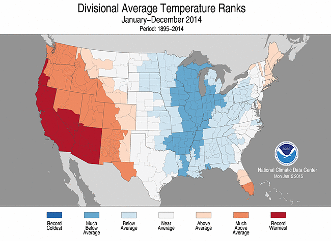
Graphic Preview

Additional Metadata
| Resource Type | Dataset |
|---|---|
| Metadata Date | June 23, 2023 |
| Metadata Created Date | October 28, 2022 |
| Metadata Updated Date | September 19, 2023 |
| Reference Date(s) | March 1, 2014 (publication), March 15, 2015 (revision), November 15, 2018 (revision) |
| Responsible Party | NOAA National Centers for Environmental Information (Point of Contact); DOC/NOAA/NESDIS/NCEI > National Centers for Environmental Information, NESDIS, NOAA, U.S. Department of Commerce (Point of Contact) |
| Contact Email | |
| Guid | gov.noaa.ncdc:C00005 |
| Category Tag 16E15F51 D96E 4051 9124 75665Abdc6Ff | ["Atmospheric, Earth and Ocean Sciences","Transportation","Physical Data","Water","Human Health","Ecosystem Vulnerability"] |
| Access Constraints | Cite as: Vose, Russell S.; Applequist, Scott; Squires, Mike; Durre, Imke; Menne, Matthew J.; Williams, Claude N., Jr.; Fenimore, Chris; Gleason, Karin; Arndt, Derek (2014): NOAA Monthly U.S. Climate Divisional Database (NClimDiv). [indicate subset used]. NOAA National Climatic Data Center. doi:10.7289/V5M32STR [access date]., Distribution liability: NOAA and NCEI make no warranty, expressed or implied, regarding these data, nor does the fact of distribution constitute such a warranty. NOAA and NCEI cannot assume liability for any damages caused by any errors or omissions in these data. If appropriate, NCEI can only certify that the data it distributes are an authentic copy of the records that were accepted for inclusion in the NCEI archives., Use liability: NOAA and NCEI cannot provide any warranty as to the accuracy, reliability, or completeness of furnished data. Users assume responsibility to determine the usability of these data. The user is responsible for the results of any application of this data for other than its intended purpose. |
| Bbox East Long | -66.0 |
| Bbox North Lat | 71.5 |
| Bbox South Lat | 24.0 |
| Bbox West Long | -180.0 |
| Coupled Resource | |
| Frequency Of Update | monthly |
| Graphic Preview Description | Divisional Average Temperature Ranks, January-December 2014 |
| Graphic Preview File | https://www.ncei.noaa.gov/pub/data/metadata/images/C00005.gif |
| Graphic Preview Type | GIF |
| Harvest Object Id | db72c52e-8628-4b13-b501-719e3b13146d |
| Harvest Source Id | 2cb3ef77-1683-4c2a-9119-dc65e50917c6 |
| Harvest Source Title | ncdc |
| Licence | Data is derived from all observations available at the time of data production. |
| Lineage | This dataset exhibits substantial differences with the previous Climate Divisional Dataset over the period 1895-2013. The first improvement is to the input data, which now include additional station records and contemporary bias adjustments (Menne and Williams, 2009). The second improvement is to the suite of climatic elements, which has been expanded to include both maximum and minimum temperature. The final (and far most extensive) improvement is to the computational methodology, which now addresses topographic and network variability via climatologically aided interpolation (Willmott and Robeson, 1995). |
| Metadata Language | eng; USA |
| Metadata Type | geospatial |
| Old Spatial | {"type": "Polygon", "coordinates": [[[-180.0, 24.0], [-66.0, 24.0], [-66.0, 71.5], [-180.0, 71.5], [-180.0, 24.0]]]} |
| Progress | onGoing |
| Spatial Data Service Type | |
| Spatial Reference System | |
| Spatial Harvester | True |
| Temporal Extent Begin | 1895-01-01 |
Didn't find what you're looking for? Suggest a dataset here.

