Wikipedia:Graphics Lab/Map workshop/Archive/Dec 2020
Latest comment: 4 years ago by Al Ameer son in topic Coloring adjustment for map, per FAC recommendation
| This is an archive of past discussions on Wikipedia:Graphics Lab, for the period 2020. Do not edit the contents of this page. If you wish to start a new discussion or revive an old one, please do so on the current main page. |

Request for Correction in Maps of India
-
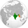 Correct Map showing locations of India and Myanmar
 -
 India - Bhutan
 Done by User:RexxS, thanks!
 -
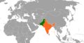 Incorrect Map showing locations of India and Pakistan


- Article(s)
- Bhutan–India relations, India–Pakistan relations
- Request
- Details of your request go here… As it can be seen, disputed territories of Kashmir are correctly shown in the first map, but, not so in other two maps. Hence, it is requested that corrected maps be created. Also, relevant discussion on related article's talk pages:
- 1. India-Bhutan
- 2. India-Pakistan
Dhawangupta (talk) 09:10, 3 December 2020 (UTC)
- Discussion
The Boat Race 2021 course
- Article(s)
- The Boat Race 2021
- Request
- Unusual times, but this year the Boat Race is being held on the River Great Ouse as opposed to the Thames, and I'd like a map to reflect the course. The official website has a crude course map and I've found the two (appropriately licensed) Ordnance Survey maps which cover it (TL58SE and TL58NE). I guess ideally the two images need to be tiled and then the result cropped down, and finally the course overlaid on top per the official website. Cheers. The Rambling Man (Stay alert! Control the virus! Save lives!!!!) 15:27, 14 January 2021 (UTC)
- Discussion
-
- Hi, @The Rambling Man:, happy to sort this one out.
 Request taken by Amitchell125 (talk) 17:50, 25 January 2021 (UTC).
- Amitchell125 Yay, that's brilliant news. Thanks, let me know if you need any more information? Cheers. The Rambling Man (Stay alert! Control the virus! Save lives!!!!) 17:52, 25 January 2021 (UTC)
- @The Rambling Man: The map I've produced can be found here. Please let me know of any amendments you think need to be made, as almost anything can be altered. Done Amitchell125 (talk) 21:06, 25 January 2021 (UTC)
- Amitchell125 that's just spot on, thanks for your help and thanks for getting it done so quickly, very much appreciated! The Rambling Man (Stay alert! Control the virus! Save lives!!!!) 21:08, 25 January 2021 (UTC)
- @The Rambling Man: Cheers! Amitchell125 (talk) 21:10, 25 January 2021 (UTC)
- {{Resolved}}
- @The Rambling Man: Cheers! Amitchell125 (talk) 21:10, 25 January 2021 (UTC)
- Amitchell125 that's just spot on, thanks for your help and thanks for getting it done so quickly, very much appreciated! The Rambling Man (Stay alert! Control the virus! Save lives!!!!) 21:08, 25 January 2021 (UTC)
- @The Rambling Man: The map I've produced can be found here. Please let me know of any amendments you think need to be made, as almost anything can be altered.
- Amitchell125 Yay, that's brilliant news. Thanks, let me know if you need any more information? Cheers. The Rambling Man (Stay alert! Control the virus! Save lives!!!!) 17:52, 25 January 2021 (UTC)
- Hi, @The Rambling Man:, happy to sort this one out.
Coloring adjustment for map, per FAC recommendation
-
 Map of different stages of the early Muslim conquests, centered on northern Iran for emphasis on that region.
.jpg)
- Article(s)
- Sulayman ibn Abd al-Malik
- Request
- In the course of the current FAC of Sulayman ibn Abd al-Malik, it was suggested in the Image Review that the difference between the green vs lime green-shaded areas of the map be improved for clarity, and further, I think the difference between the dark brown and light brown should also be improved. Perhaps its best that the lime green and light brown be replaced with entirely different colors: lime green → orange, light brown → purple. I am not able to do this without botching the map. Any help is appreciated. Thank you. -- Al Ameer (talk) 04:58, 18 January 2021 (UTC)
- Discussion
Hi @Al Ameer son: - As far as I know your request can't easily be done without making a new map. I can help you, but I'll look first to see how big the task is before committing. Regards, Amitchell125 (talk) 19:02, 24 January 2021 (UTC)
- Thank you for considering this request Amitchell125 and yes, please let me know. I personally think it may be too much trouble. If you confirm, I’ll move to the alternative of using File:Northern Iran and its surroundings during the Iranian intermezzo.svg. Al Ameer (talk) 02:40, 25 January 2021 (UTC)
- No, had a look and it's not too much trouble, I'll get started on it. Amitchell125 (talk) 09:04, 25 January 2021 (UTC)
- @Al Ameer son: All done (here) - let me know of anything that needs to be amended. Regards - and good luck with the article. Done Amitchell125 (talk) 21:34, 25 January 2021 (UTC)
- @Amitchell125: Replied at my talk page. Thanks again for your efforts here. Regards --Al Ameer (talk) 22:20, 25 January 2021 (UTC)
- {{Resolved}}
- @Amitchell125: Replied at my talk page. Thanks again for your efforts here. Regards --Al Ameer (talk) 22:20, 25 January 2021 (UTC)
- @Al Ameer son: All done (here) - let me know of anything that needs to be amended. Regards - and good luck with the article.
- No, had a look and it's not too much trouble, I'll get started on it. Amitchell125 (talk) 09:04, 25 January 2021 (UTC)