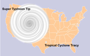
Typhoon Tip is the most intense and largest tropical cyclone on record. This 1979 storm caused widespread flood damage across most of Japan.

The cyclone formed in the northwestern Pacific Ocean on October 5, 1979 as Tropical Depression 23. It strengthened to Tropical Storm status on October 6, and became a Typhoon on October 9. After moving into a very favorable environment for development, Typhoon Tip quickly strengthened into Super Typhoon Tip on October 11 and its pressure dropped from 996 to 898 millibars. It was during this time that Tip's diameter reached a record 1,350 miles (2,170 km) wide, with tropical storm force winds extending 675 miles (1,085 km) from the center. To put it another way, if a similar-sized hurricane hit south Florida directly, tropical storm force winds would be felt as far north as Charlotte, North Carolina and as far south as Merida, Mexico and Kingston, Jamaica. On October 12, Super Typhoon Tip continued to intensify, with winds at 190 miles per hour and central pressure at 870 millibars, the lowest barometric pressure ever recorded in a tropical cyclone.
After reaching its peak on the 12th, Tip slowly weakened as it headed toward Japan. It made landfall on Honshu on October 19 as a minimal typhoon but nonetheless caused significant damage. Tip cost the agricultural and fishing industries of Japan millions of dollars in damage. There were 68 deaths from Tip, including many due to floods that breached a fuel retaining wall in Camp Fuji.
References
- Murray, T.R. & Morford, D.R. (1980). 1979 Annual Typhoon Report (.pdf file)
- Typhoon Tip's track: http://weather.unisys.com/hurricane/w_pacific/1979/23/track.gif