Wikipedia:Graphics Lab/Map workshop/Archive/Mar 2010
Stale
More Range Maps
-
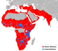
 Cheetah Range
 -
 Leopard
 -
 Puma
Puma -
 Puma, SVG
 -
 Lion
Lion -
 Bornean Clouded Leopard
 -
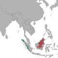 Bornean Clouded Leopard, SVG
 -
 Clouded leopard


Article(s): Cheetah, Leopard, Puma, Lion, Bornean Clouded leopard, Clouded Leopard
Request: Vectorize. I'll give a barnstar to anyone who even can manage to get half done. Connormah (talk) 05:15, 7 December 2009 (UTC)
Graphist opinion(s):![]() Request taken by Mononomic. Be back in a bit. Mononomic (talk) 01:30, 1 January 2010 (UTC)
Request taken by Mononomic. Be back in a bit. Mononomic (talk) 01:30, 1 January 2010 (UTC)
- One is done, File:Neofelis diardi Locator Map.svg. Mononomic (talk) 02:58, 1 January 2010 (UTC)
- And another, File:Puma concolor Location Map.svg. Whew, this is tiring! Not sure if I'll keep this up, so removing "I take" template so someone else can work on this too. Hope this helps! Mononomic (talk) 03:57, 1 January 2010 (UTC)
Resolved
Lake Chad water level map
-
Chad lake water level 1975-2010
-
 Lake Chad water area and levels 1972 - 2007

Article(s): Lake Chad
Request: A map of the Chad lake water levels should be made based on the images at http://blogs.nationalgeographic.com/blogs/news/chiefeditor/2010/02/lake-chad-ramsar-convention.html. The map http://commons.wikimedia.org/wiki/File:BlankMap-World-v6.png can be used onto which the lake is drawn; the lake needs to have 2 colors (showing the current level and the wateramount of the lake which has been removed) KVDP (talk) 11:10, 8 February 2010 (UTC)
Graphist opinion(s):
Quite hard as the latest level 2007 is not much bigger than the 1987 level. Hopefully meets requirements of the request.
If changes are needed, such as removing one of the layers or spacing the text, by all means get in touch :¬)
![]() Request taken by Chaosdruid.
Request taken by Chaosdruid.
![]() Done:Chaosdruid (talk) 04:56, 28 February 2010 (UTC)
Done:Chaosdruid (talk) 04:56, 28 February 2010 (UTC)