Wikipedia:Graphics Lab/Map workshop/Archive/Mar 2010
Stale
More Range Maps
-
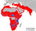
 Cheetah Range
 -
 Leopard
 -
 Puma
Puma -
 Puma, SVG
 -
 Lion
Lion -
 Bornean Clouded Leopard
 -
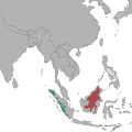 Bornean Clouded Leopard, SVG
 -
 Clouded leopard


Article(s): Cheetah, Leopard, Puma, Lion, Bornean Clouded leopard, Clouded Leopard
Request: Vectorize. I'll give a barnstar to anyone who even can manage to get half done. Connormah (talk) 05:15, 7 December 2009 (UTC)
Graphist opinion(s):![]() Request taken by Mononomic. Be back in a bit. Mononomic (talk) 01:30, 1 January 2010 (UTC)
Request taken by Mononomic. Be back in a bit. Mononomic (talk) 01:30, 1 January 2010 (UTC)
- One is done, File:Neofelis diardi Locator Map.svg. Mononomic (talk) 02:58, 1 January 2010 (UTC)
- And another, File:Puma concolor Location Map.svg. Whew, this is tiring! Not sure if I'll keep this up, so removing "I take" template so someone else can work on this too. Hope this helps! Mononomic (talk) 03:57, 1 January 2010 (UTC)
ASEAN–China Free Trade Area

Article(s): ASEAN–China Free Trade Area
Request: Either remove non-ASEAN surrounding countries, or include all per Wiki standards, and remove smaller map as it is not germane to ASEAN... Chris (クリス • フィッチュ) (talk) 10:03, 2 January 2010 (UTC)
Graphist opinion(s):
Pacific-centered Mercator projection map with national boundaries for Wikification
-
 according to Mercator perspective

</gallery>
Article(s): several articles could use the map]]
Request: create new version (or fix this one) to clearly show national boundaries in white, so the map is colorable according to Wikipedia standards/or/create new version according to the "Pacific Ocean centered" map at http://english.freemap.jp/world_e/8.html ... Chris (クリス • フィッチュ) (talk) 10:48, 23 December 2009 (UTC)
Graphist opinion:
Comment: the national boundaries are on there, just not visible at thumbnail size, so it is colorable as is - creating a version with wider white boundaries from this one should be possible. Kmusser (talk) 18:49, 23 December 2009 (UTC)
- I would name children after you if you could. Chris (クリス • フィッチュ) (talk) 22:55, 1 January 2010 (UTC)
- I made an attempt but that file keeps crashing Inkscape, it might be due to the large file size - if someone with a better computer wants to try, it would be appreciated. Kmusser (talk) 20:47, 7 January 2010 (UTC)
- Thank you for trying, is there a way to reduce the size first? Chris (クリス • フィッチュ) (talk) 04:10, 8 January 2010 (UTC)
- Yeah, it could be edited in a text editor, but that's beyond my crude SVG skills. Kmusser (talk) 04:14, 8 January 2010 (UTC)
Resolved
Lake Chad water level map
-
Chad lake water level 1975-2010
-
 Lake Chad water area and levels 1972 - 2007

Article(s): Lake Chad
Request: A map of the Chad lake water levels should be made based on the images at http://blogs.nationalgeographic.com/blogs/news/chiefeditor/2010/02/lake-chad-ramsar-convention.html. The map http://commons.wikimedia.org/wiki/File:BlankMap-World-v6.png can be used onto which the lake is drawn; the lake needs to have 2 colors (showing the current level and the wateramount of the lake which has been removed) KVDP (talk) 11:10, 8 February 2010 (UTC)
Graphist opinion(s):
Quite hard as the latest level 2007 is not much bigger than the 1987 level. Hopefully meets requirements of the request.
If changes are needed, such as removing one of the layers or spacing the text, by all means get in touch :¬)
- Excellent; thanks Chaosdruid. Regarding the world map, I opted for this as it would allow the marking of other lakes,... ie to demonstrate how the reducing water levels of several lakes, ... affect each other. I think however that the map of the entire continent Africa will suffice to allow such use for future images. Regarding the coloring I actually prefered only blue and red (or dark blue, light blue and red), but this will do aswell.
KVDP (talk) 13:14, 8 March 2010 (UTC)
![]() Request taken by Chaosdruid.
Request taken by Chaosdruid.
![]() Done:Chaosdruid (talk) 04:56, 28 February 2010 (UTC)
Done:Chaosdruid (talk) 04:56, 28 February 2010 (UTC)
Map of World War II Japanese American internment camps

Article(s): Japanese American internment
Request: Trim away extra blank space on right side which skews map... Chris (クリス • フィッチュ) (talk) 09:43, 1 March 2010 (UTC)
Graphist opinion(s):
![]() Done manually cropped with gimp. --Erp (talk) 14:59, 1 March 2010 (UTC)
Done manually cropped with gimp. --Erp (talk) 14:59, 1 March 2010 (UTC)
- Great, thank you! --Chris (クリス • フィッチュ) (talk) 05:24, 2 March 2010 (UTC)
Mount Kenya Population map


Article(s):
Request: Make an English-language version, without the border... Chris (クリス • フィッチュ) (talk) 04:30, 28 February 2010 (UTC)
Graphist opinion(s):
![]() Request taken by Erp. working on this. Put an English version beside above. How does it look?--Erp (talk) 06:05, 3 March 2010 (UTC)
Request taken by Erp. working on this. Put an English version beside above. How does it look?--Erp (talk) 06:05, 3 March 2010 (UTC)
- Perfect, thank you! --Chris (クリス • フィッチュ) (talk) 12:45, 3 March 2010 (UTC)
Pornography law map

Article(s):
Request: #2 should be uploaded on top of #1, rather than a new file created for each change-please combine... Chris (クリス • フィッチュ) (talk) 02:32, 28 February 2010 (UTC)
- Anyway we can get sources for this map or some baseline for "Legal" vs. "Legal, with restrictions". Legal obviously allows for some illegalities (child, animal, etc.) but what is the line? From what I recall Japan has some censorship laws which go beyond the normal "legal"... I think we'd have to justify our cut off between the two? (Not as much for Indian but Australia vs. Japan). gren グレン 18:29, 28 February 2010 (UTC)
Graphist opinion(s):
 Done: Done, both are at File:Pornography law map.png. I cannot update the hu.wiki to point to the single file because the page is locked. I have marked the duplicates as duplicates on the Commons. -- RA (talk) 23:07, 3 March 2010 (UTC)
- Thank you, that's all I needed. I don't know about all the issues and all, but it just needed to be reduced to a single file, thanks! --Chris (クリス • フィッチュ) (talk) 12:57, 4 March 2010 (UTC)