File:100 Years War France 1435-es.svg

Dimensioni di questa anteprima PNG per questo file SVG: 601 × 599 pixel. Altre risoluzioni: 241 × 240 pixel | 482 × 480 pixel | 770 × 768 pixel | 1 027 × 1 024 pixel | 2 055 × 2 048 pixel | 948 × 945 pixel.
File originale (file in formato SVG, dimensioni nominali 948 × 945 pixel, dimensione del file: 49 KB)
| Questo file e la sua pagina di descrizione (discussione · modifica) si trovano su Wikimedia Commons (?) |
Dettagli
| Descrizione |
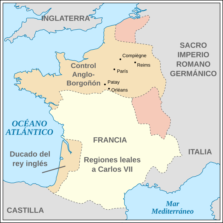
English: France during the 100 Years' War in 1435. *Coastline from a 1991 CIA map. *Relief shading based on GLOBE data. *Country borders from File:Hundred years war france england 1435.jpg. *City locations based on Lat/Long data in their Wikipedia entries, which are further sourced from open projects. (Included in svg point descriptions.)
Español: Francia durante la Guerra de los Cien Años, en 1435. |
| Data | (UTC) |
| Fonte |
Questo file deriva da: 100 Years War France 1435.svg:  |
| Autore |
|
| Altre versioni |
[]
|


| Questa è una immagine ritoccata, il che significa che è stata modificata digitalmente dalla sua versione originale. Modifiche: translated into Spanish. La versione originale può essere vista qui: 100 Years War France 1435.svg. Le modifiche sono di Rowanwindwhistler.
|
Licenza
Questo file è disponibile in base alla licenza Creative Commons Attribuzione-Condividi allo stesso modo 3.0 Unported
- Tu sei libero:
- di condividere – di copiare, distribuire e trasmettere quest'opera
- di modificare – di adattare l'opera
- Alle seguenti condizioni:
- attribuzione – Devi fornire i crediti appropriati, un collegamento alla licenza e indicare se sono state apportate modifiche. Puoi farlo in qualsiasi modo ragionevole, ma non in alcun modo che suggerisca che il licenziante approvi te o il tuo uso.
- condividi allo stesso modo – Se remixi, trasformi o sviluppi il materiale, devi distribuire i tuoi contributi in base alla stessa licenza o compatibile all'originale.
Registro originale del caricamento
This image is a derivative work of the following images:
- File:100_Years_War_France_1435.svg licensed with Cc-by-sa-3.0, GFDL
- 2011-07-11T06:19:49Z Foxyshadis 948x945 (49946 Bytes) Add the locations of other cities related to Joan of Arc, both important battles & sieges and her execution. Domrémy is excluded as unrelated to the war.
- 2010-11-19T07:07:25Z PaulVIF 948x945 (42933 Bytes) {{Translation possible}} [[Category:Maps of the Hundred Years' War]] [[Category:Maps of the history of France]] == {{int:license}} == {{self|cc-by-sa-3.0|GFDL}}
- 2010-11-18T10:52:27Z PaulVIF 948x945 (45139 Bytes) {{Translation possible}} [[Category:Maps of the Hundred Years' War]] [[Category:Maps of the history of France]] == {{int:license}} == {{self|cc-by-sa-3.0|GFDL}}
- 2009-09-03T10:24:40Z Mysid 948x945 (45061 Bytes) remove ugly shading...
- 2009-09-03T10:22:09Z Mysid 948x945 (3208275 Bytes) {{Information |Description={{en|1=France during the 100 Years' War in 1435. *Coastline from a 1991 CIA map. *Relief shading based on GLOBE data. *Country borders from [[:File:Hundred years war france england 1435.jpg]].}} |So
Uploaded with derivativeFX
Cronologia del file
Fare clic su un gruppo data/ora per vedere il file come si presentava nel momento indicato.
| Data/Ora | Miniatura | Dimensioni | Utente | Commento | |
|---|---|---|---|---|---|
| attuale | 12:11, 4 lug 2013 | | 948 × 945 (49 KB) | Rowanwindwhistler | == {{int:filedesc}} == {{Information |Description={{en|1=France during the 100 Years' War in 1435. *Coastline from a 1991 CIA map. *Relief shading based on GLOBE data. *Country borders from File:Hundred years war france england 1435.jpg. *City loc... |
Pagine che usano questo file
Nessuna pagina utilizza questo file.
Utilizzo globale del file
Anche i seguenti wiki usano questo file:
- Usato nelle seguenti pagine di en.wikipedia.org:
- Usato nelle seguenti pagine di es.wikipedia.org: