Fisiye:Ancient peloponnese-it.svg

Size of this PNG preview of this SVG file: 583 × 599 pixels. A to resolutions: 233 × 240 pixels | 467 × 480 pixels | 747 × 768 pixels | 996 × 1,024 pixels | 1,992 × 2,048 pixels | 778 × 800 pixels
Fisiye menga (SVG file, nominally 778 × 800 pixels, file size: 84 KB)
Kʋmbgo
| Bilsi |
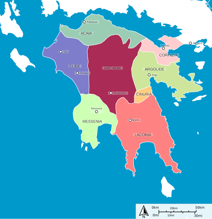
English: Ancient peloponnese map Italiano: Mappa dell'antico Peloponneso |
| Daarenga | (UTC) |
| Sɩngre |
This file was derived from: Ancient peloponnese.svg:  |
| Gulsda |
|
| Other versions |
[]
|


| This is a retouched picture, which means that it has been digitally altered from its original version. Modifications: Italian translation. The original can be viewed here: Ancient peloponnese.svg:
|
Sor-kũuni
I, the copyright holder of this work, hereby publish it under the following licenses:
Yao fisiye la Kaset sebre tengre ku Creative Commons Attribution-Share Alike 3.0 Unported kaset sebre.
- Fo vʋʋse sa mi
- n pʋɩ – Gese n gulse, pʋɩ la kis tumda ti kẽnge
- n kalme – zemse tumde
- Yɛl pʋgdse tẽngre:
- zu-lukri – Fo toge kõ waoogre sɛgde, wilgi tokre ni sor-kũuni, la wilgi baa-ti tekre da maana mi. Fo na tõe maane boto ni yam, la pa sore ning wilgi ti sor-kũuna sake ni fo bɩɩ fo tʋʋma.
- pʋɩ zem-taaba – Fo sãn lebe-kalme,teeme,bɩɩ m me bõn zugu, fo toge pʋɩ fo lobre tẽngre ni taare bɩɩ zeme kaset sebre ni a mêng mênga.

|
Sore-kõ mi ti fo gʋs-n-gʋlse, n-pʋɩ la/bii fo yélé sebre kada ni bãngre kada tengre GNU gʋlse zaalem sɩngre, sɛba 1.2 bii sɛb ning n moone ni Free Software Foundation; pa-tekre zĩig takɩ, pa toore-ludri gʋlsga, la pa poore
Ɩudri gʋlsgo. Ges-guɩs sôr-kũunĩ paasa ni zĩig takɩ zugu GNU Free Documentation License. |
Fo tõe yãka sor-kũuni fo sẽn data.
Original upload log
This image is a derivative work of the following images:
- File:Ancient_peloponnese.svg licensed with Cc-by-sa-3.0, GFDL
- 2012-07-25T23:26:33Z Jkan997 778x800 (73432 Bytes) Added some cities
- 2012-07-25T23:19:25Z Jkan997 778x800 (71445 Bytes) {{Information |Description ={{en|1=Ancient peloponnese }} |Source = http://sharemap.org/public/Ancient_peloponnese Geospatial data sources: *Open Street Map Data (CC-SA-BY) - http://wiki.openstreetmap.org/wiki/OpenStreetMap_
Fisiye kibare
Didge daare/wakata n gese fisiye yii wakate kãngã
| Daare/Wakate | Marsã | Nen-magdem | Tʋmtʋmda | Koɛɛga | |
|---|---|---|---|---|---|
| marsã | 10:40, 30 Zĩ-likr kiuugu 2013 | | 778 × 800 (84 KB) | Fulvio314 | + Cinuria |
| 10:07, 30 Zĩ-likr kiuugu 2013 |  | 778 × 800 (83 KB) | Fulvio314 | {{Information |Description={{en|1=Ancient peloponnese map}} {{it|1=Mappa dell'antico Peloponneso}} |Source={{Derived from|Ancient_peloponnese.svg|display=50}} |Date=2013-10-30 10:04 (UTC) |Author=*File:Ancient_peloponnese.svg: User:Jkan997 *deriv... |
Fisiye tʋʋma
Nense ka be n tʋʋde ni fisiye kada.
Andũni fisiye tʋʋma
Wikis zẽnga tʋm na ni fisiye:
- Tarek teague it.wikipedia.org