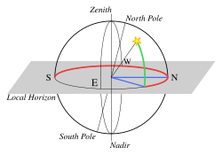
File:Horizontal coordinate system 2.svg

Size of this PNG preview of this SVG file: 629 × 440 pixels. Other resolutions: 320 × 224 pixels | 640 × 448 pixels | 1,024 × 716 pixels | 1,280 × 895 pixels | 2,560 × 1,791 pixels.
Original file (SVG file, nominally 629 × 440 pixels, file size: 36 KB)
File history
Click on a date/time to view the file as it appeared at that time.
| Date/Time | Thumbnail | Dimensions | User | Comment | |
|---|---|---|---|---|---|
| current | 17:57, 15 May 2025 |  | 629 × 440 (36 KB) | Manlleus | File uploaded using svgtranslate tool (https://svgtranslate.toolforge.org/). Added translation for ca. |
| 20:24, 13 May 2016 |  | 590 × 412 (22 KB) | CheChe | Thickened red line | |
| 18:49, 13 May 2016 |  | 590 × 412 (22 KB) | CheChe | Corrected South pole line | |
| 18:40, 13 May 2016 |  | 590 × 412 (22 KB) | CheChe | Darkened the plane so that it's easier to see. | |
| 18:33, 13 May 2016 |  | 590 × 412 (22 KB) | CheChe | User created page with UploadWizard |
File usage
There are no pages that use this file.
Global file usage
The following other wikis use this file:
- Usage on ast.wikipedia.org
- Usage on ca.wikipedia.org
- Usage on en.wikipedia.org
- Usage on en.wikiversity.org
- Usage on es.wikipedia.org
- Usage on eu.wikipedia.org
- Usage on fa.wikibooks.org
- Usage on gl.wikipedia.org
- Usage on is.wikipedia.org
- Usage on pt.wikipedia.org
- Usage on sh.wikipedia.org


