
Size of this PNG preview of this SVG file: 700 × 600 pixels. Other resolutions: 280 × 240 pixels | 560 × 480 pixels | 896 × 768 pixels | 1,195 × 1,024 pixels | 2,389 × 2,048 pixels.
Original file (SVG file, nominally 896 × 768 pixels, file size: 880 KB)
| This is a file from the Wikimedia Commons. Information from its description page there is shown below. Commons is a freely licensed media file repository. You can help. |
Summary
| Description |
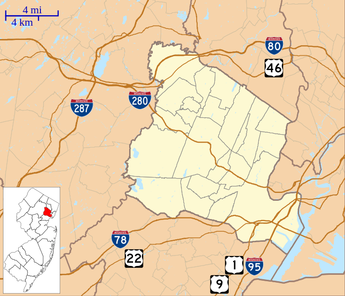
English: This is a map of Essex County, New Jersey, USA which includes incorporated settlements, township borders, and major highways. |
| Date | |
| Source | My own work, using custom-written MapScript applications with United States Census Bureau data |
| Author | Omnedon |
Licensing
| I, the copyright holder of this work, release this work into the public ___domain. This applies worldwide. In some countries this may not be legally possible; if so: I grant anyone the right to use this work for any purpose, without any conditions, unless such conditions are required by law. |
File history
Click on a date/time to view the file as it appeared at that time.
| Date/Time | Thumbnail | Dimensions | User | Comment | |
|---|---|---|---|---|---|
| current | 15:56, 6 October 2012 | | 896 × 768 (880 KB) | Omnedon | == {{int:filedesc}} == {{Information |Description={{en|This is a map of Essex County, New Jersey, USA which includes incorporated settlements, township borders, and major highways.}} |Source=My own work, using custom-wri... |
File usage
More than 100 pages use this file. The following list shows the first 100 pages that use this file only. A full list is available.
- Ambrose-Ward Mansion
- Belleville, New Jersey
- Belleville Avenue Congregational Church
- Belleville Dutch Reformed Church
- Bethany Baptist Church (Newark, New Jersey)
- Bloomfield, New Jersey
- Branch Brook Park
- Caldwell, New Jersey
- Catedral Evangelica Reformada
- Cedar Grove, New Jersey
- Central Presbyterian Church (Montclair, New Jersey)
- Church Street School (Nutley, New Jersey)
- Cliffside Hose Company No. 4
- Congregation B'nai Israel (Millburn, New Jersey)
- Congregational Church (Montclair, New Jersey)
- Crane House and Historic YWCA
- Eagle Rock Reservation
- East Orange, New Jersey
- Eberhardt Hall, New Jersey Institute of Technology
- Essex County Courthouse
- Essex Fells, New Jersey
- Essex Park, New Jersey
- Fairfield Dutch Reformed Church
- Fairfield Township, Essex County, New Jersey
- First Baptist Peddie Memorial Church
- First Methodist Episcopal Church (Montclair, New Jersey)
- Forest Hill, Newark, New Jersey
- Glen Ridge, New Jersey
- Grace Church (Newark)
- Grover Cleveland Birthplace
- Hahne and Company
- House of Prayer Episcopal Church and Rectory
- Indian and the Puritan
- Irvington, New Jersey
- John Ballantine House
- Kingsland Manor
- Kip's Castle Park
- Lincoln Park, Newark
- Livingston, New Jersey
- Llewellyn Park
- Maplewood, New Jersey
- Military Park (Newark)
- Millburn, New Jersey
- Montclair, New Jersey
- Montclair Art Museum
- Mutual Benefit Life Insurance Company
- New Jersey Historical Society
- New Point Baptist Church
- Newark, New Jersey
- Newark City Hall
- Newark Female Charitable Society
- Newark Public Library
- North Caldwell, New Jersey
- North Reformed Church
- Nutley, New Jersey
- Oakes Estate
- Oheb Shalom Congregation
- Old First Presbyterian Church (Newark, New Jersey)
- Orange, New Jersey
- Pan American C.M.A. Church
- Presby Memorial Iris Gardens
- Pro-Cathedral of Saint Patrick in Newark
- Queen of Angels Church (Newark)
- Riker Hill Fossil Site
- Riverbank Park
- Roseland, New Jersey
- Samuel Orton Harrison House
- Second Reformed Dutch Church
- Seton Hall University
- Short Hills, New Jersey
- Short Hills Park Historic District
- South Mountain Reservation
- South Orange, New Jersey
- South Orange Fire House
- South Orange Village Hall
- South Park Calvary United Presbyterian Church
- St. Casimir's Roman Catholic Church (Newark, New Jersey)
- St. Columba's Church, Newark
- St. James' A. M. E. Church (Newark, New Jersey)
- St. John's Church (Newark, New Jersey)
- St. Joseph's Roman Catholic Church Rectory and School
- St. Lucy's Church (Newark, New Jersey)
- St. Luke's Church (Montclair, New Jersey)
- St. Mark's Episcopal Church (West Orange, New Jersey)
- St. Mary's Abbey Church
- St. Rocco's Roman Catholic Church
- St. Stephan's Church (Ironbound, Newark, New Jersey)
- Sydenham House, Essex County
- Temple B'nai Abraham
- Temple Emanu-El of West Essex
- The House that Lives
- The Newark Museum of Art
- Trinity & St. Philip's Cathedral (Newark, New Jersey)
- Upper Montclair, New Jersey
- Van Vleck House and Gardens
- Verona, New Jersey
- Vreeland Homestead
- Wars of America
- Weequahic Park
- West Caldwell, New Jersey
View more links to this file.
Global file usage
The following other wikis use this file:
- Usage on ar.wikipedia.org
- Usage on azb.wikipedia.org
- Usage on bn.wikipedia.org
- Usage on ceb.wikipedia.org
- Usage on fa.wikipedia.org
- Usage on fr.wikipedia.org
- Usage on kn.wikipedia.org
- Usage on simple.wikipedia.org
- Usage on si.wikipedia.org
- Usage on tl.wikipedia.org
- Usage on tr.wikipedia.org
- Usage on war.wikipedia.org
- Usage on zh.wikipedia.org