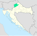
File:Location of Hrvatsko zagorje inside Croatia.svg

Size of this PNG preview of this SVG file: 677 × 600 pixels. Other resolutions: 271 × 240 pixels | 542 × 480 pixels | 867 × 768 pixels | 1,156 × 1,024 pixels | 2,311 × 2,048 pixels | 1,098 × 973 pixels.
Original file (SVG file, nominally 1,098 × 973 pixels, file size: 824 KB)
File history
Click on a date/time to view the file as it appeared at that time.
| Date/Time | Thumbnail | Dimensions | User | Comment | |
|---|---|---|---|---|---|
| current | 12:58, 29 June 2025 |  | 1,098 × 973 (824 KB) | Ashune | Cropped in to see the area better, added a minimap, added a legend |
| 14:54, 3 August 2024 |  | 1,097 × 1,062 (510 KB) | Ashune | show county borders over highlighted area, small fixes to highlight borders | |
| 12:26, 3 August 2024 |  | 1,097 × 1,062 (509 KB) | Ashune | More readable version based on Croatia ___location map.svg | |
| 11:34, 3 August 2024 |  | 900 × 900 (3.29 MB) | Ashune | Uploaded own work with UploadWizard |
File usage
There are no pages that use this file.
Global file usage
The following other wikis use this file:
- Usage on de.wikipedia.org
- Usage on en.wikipedia.org
- Usage on hr.wikipedia.org
- Usage on sh.wikipedia.org
- Usage on sl.wikipedia.org
- Usage on uk.wikipedia.org
- Usage on www.wikidata.org