No higher resolution available.
Map_of_Amazonis.JPG (636 × 426 pixels, file size: 45 KB, MIME type: image/jpeg)
| This is a file from the Wikimedia Commons. Information from its description page there is shown below. Commons is a freely licensed media file repository. You can help. |
Summary
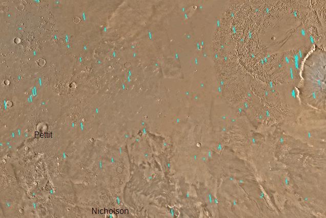
| Description |
English: Map of Amazonis quadrangle, Mars. The small, colored rectangles represent image footprints for the narrow angle camera on the Mars Global Surveyor. Some are about 1 mile wide, the otheers are about 2 miles wide. The map was made by the U.S. Geological survey for NASA. |
| Date | |
| Source | http://www.msss.com/gallery/s05_s10/mc08.html |
| Author | Jim Secosky modified NASA photo. |
Licensing
| This file is in the public ___domain in the United States because it was solely created by NASA. NASA copyright policy states that "NASA material is not protected by copyright unless noted". (See Template:PD-USGov, NASA copyright policy page or JPL Image Use Policy.) | ||
 |
Warnings:
|
Original upload log
Transferred from en.wikipedia to Commons by Magnus Manske using CommonsHelper.
The original description page was here. All following user names refer to en.wikipedia.
- 2008-12-29 19:33 Jimmarsmars 636×426× (45866 bytes) {{Information |Description=Map of Amazonis Mars |Source=http://www.msss.com/gallery/s05_s10/mc08.html |Date=December 29, 2008 |Author=Jim Secosky modified NASA photo. |Permission= |other_versions= }}
File history
Click on a date/time to view the file as it appeared at that time.
| Date/Time | Thumbnail | Dimensions | User | Comment | |
|---|---|---|---|---|---|
| current | 06:46, 20 February 2011 | | 636 × 426 (45 KB) | File Upload Bot (Magnus Manske) | {{BotMoveToCommons|en.wikipedia|year={{subst:CURRENTYEAR}}|month={{subst:CURRENTMONTHNAME}}|day={{subst:CURRENTDAY}}}} {{Information |Description={{en|Map of Amazonis quadrangle, Mars. The small, colored rectangles represent image footprints for the nar |
File usage
The following page uses this file:
Global file usage
The following other wikis use this file:
- Usage on ca.wikipedia.org
- Usage on es.wikipedia.org
- Usage on hi.wikipedia.org
- Usage on www.wikidata.org
- Usage on zh.wikipedia.org