File originale (file in formato SVG, dimensioni nominali 407 × 345 pixel, dimensione del file: 42 KB)
Logo di Commons
Logo di Commons
Questo file e la sua pagina di descrizione (discussione · modifica) si trovano su Wikimedia Commons (?)

Dettagli

Descrizione
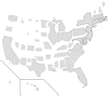
English: This request originated from the Illustration workshop, and was solved mathematically using the data at the linked article. By definition, the population density is the population divided by area, or:
or, equivalently,

We want to resize each state according to its population, so each state's new area will be defined by a new (constant) population density, :

We can substitute for in the above expression to get:

This means the new area is simply the existing area multiplied by an areal scaling factor . Since area is the product of two dimensions, we can apply an equal scaling factor in each dimension (which is what the SVG expects) by taking the square root of the areal scaling factor:

I took the new population density to be equal to the 2013 population density of New Jersey, 1,210.1 persons per square mile, which in essence normalizes the scaling factor to New Jersey. For instance, California has a 2013 population density of 246.1 persons per square mile, so:

That means that I apply a scaling transformation factor of 0.451 to the California SVG object in each (x,y) dimension. When all is said and done, though, I had to end up translating most of the state SVG objects as well, so it ended up being a matrix transform (scaling + translation). When the population and/or land areas update, the updated data could be used to adjust the scaling factors in the SVG directly without having to go through a graphical editor.
Data
Fonte Opera propria, using vector source linked below.
Autore Mliu92
Altre versioni Questo file deriva da: Blank US Map.svg

Licenza

Io, detentore del copyright su quest'opera, dichiaro di pubblicarla con la seguente licenza:
w:it:Creative Commons
attribuzione condividi allo stesso modo
Tu sei libero:
  • di condividere – di copiare, distribuire e trasmettere quest'opera
  • di modificare – di adattare l'opera
Alle seguenti condizioni:
  • attribuzione – Devi fornire i crediti appropriati, un collegamento alla licenza e indicare se sono state apportate modifiche. Puoi farlo in qualsiasi modo ragionevole, ma non in alcun modo che suggerisca che il licenziante approvi te o il tuo uso.
  • condividi allo stesso modo – Se remixi, trasformi o sviluppi il materiale, devi distribuire i tuoi contributi in base alla stessa licenza o compatibile all'originale.

Didascalie

Aggiungi una brevissima spiegazione di ciò che questo file rappresenta

Elementi ritratti in questo file

raffigura

Cronologia del file

Fare clic su un gruppo data/ora per vedere il file come si presentava nel momento indicato.

Data/OraMiniaturaDimensioniUtenteCommento
attuale13:56, 16 set 2017Miniatura della versione delle 13:56, 16 set 2017407 × 345 (42 KB)MadshurtieUpdated with new boundaries from File:Blank USA, w territories.svg and File:Blank US Map (states only).svg. Removed outlines because they're ugly and got scaled proportional to population density, which isn't the most useful value.
15:15, 14 set 2017Miniatura della versione delle 15:15, 14 set 2017395 × 349 (68 KB)MadshurtieNo idea why this isn't rendering properly on wikipedia.
15:11, 14 set 2017Miniatura della versione delle 15:11, 14 set 2017395 × 349 (68 KB)MadshurtieFound the scales on the original document File:Map of USA with state names.svg to get slightly more accurate scaling factors. I have adjusted Hawaii as well.
14:50, 14 set 2017Miniatura della versione delle 14:50, 14 set 2017395 × 349 (68 KB)MadshurtieDidn't upload properly
14:41, 14 set 2017Miniatura della versione delle 14:41, 14 set 2017395 × 349 (68 KB)MadshurtieAlaska by population shouldn't be smaller than Wyoming and North Dakota. Alaska was too small because the source image File:Blank US Map.svg had a scaled-down Alaska. I have measured the pixel area of the source Alaska and calculated its ratio to...
22:18, 5 gen 2016Miniatura della versione delle 22:18, 5 gen 2016395 × 349 (68 KB)Mliu92Fixed mixup between WY/CO – thanks!
18:04, 22 set 2015Miniatura della versione delle 18:04, 22 set 2015395 × 349 (68 KB)Mliu92User created page with UploadWizard

Nessuna pagina utilizza questo file.

Utilizzo globale del file

Anche i seguenti wiki usano questo file:

Metadati