File:Regenbogen ___location map.svg

Dimensioni di questa anteprima PNG per questo file SVG: 424 × 600 pixel. Altre risoluzioni: 170 × 240 pixel | 339 × 480 pixel | 543 × 768 pixel | 724 × 1 024 pixel | 1 448 × 2 048 pixel | 744 × 1 052 pixel.
File originale (file in formato SVG, dimensioni nominali 744 × 1 052 pixel, dimensione del file: 1,92 MB)
| Questo file e la sua pagina di descrizione (discussione · modifica) si trovano su Wikimedia Commons (?) |
| Descrizione |
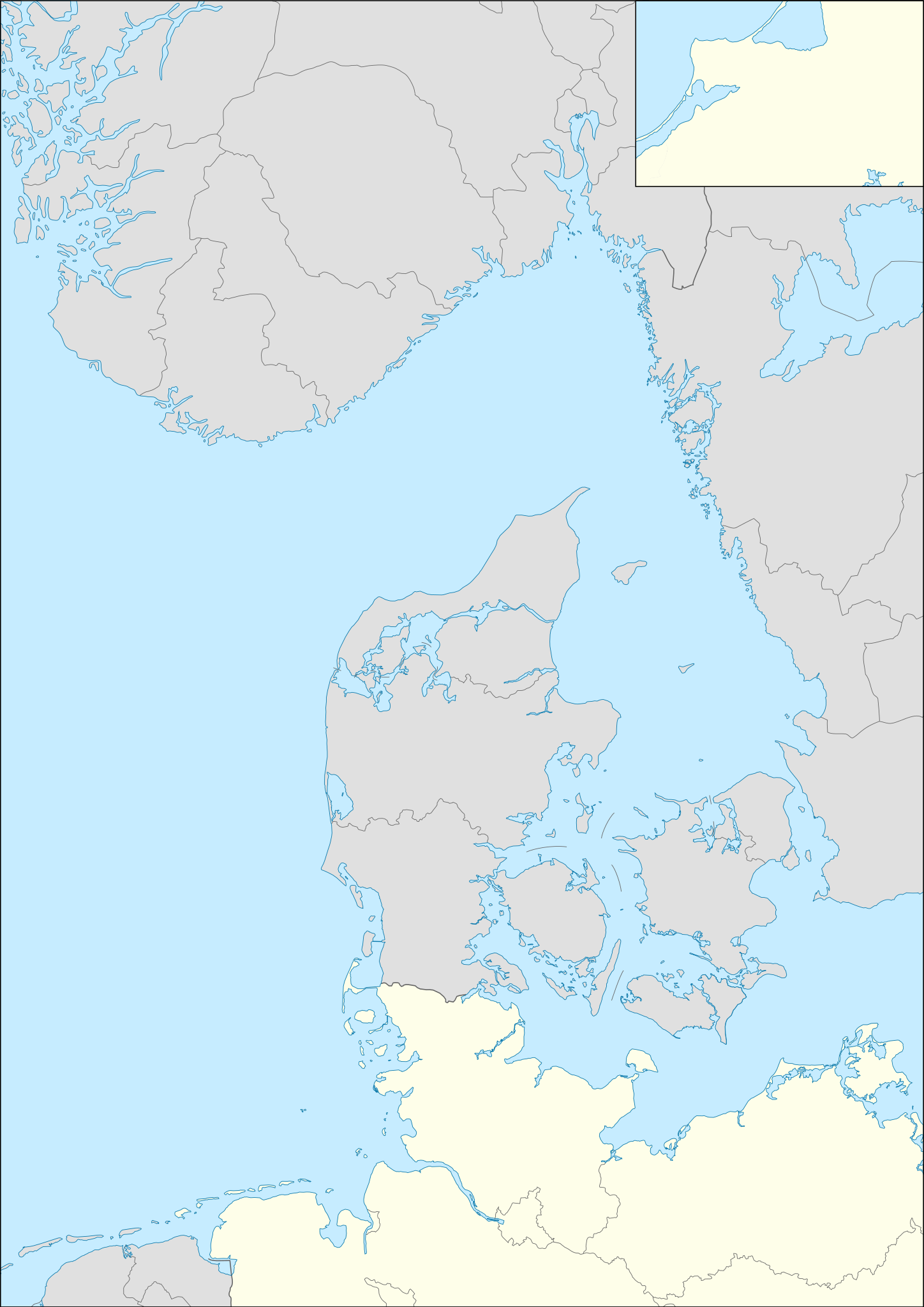
English: Location map for Operation Regenbogen Equirectangular projection. Geographic limits of the map:
|
| Data | (UTC) |
| Fonte | |
| Autore | |
| SVG sviluppo | Questa mappa in grafica vettoriale è stata creata con Inkscape, o con qualche altro programma. |
Questo file è disponibile in base alla licenza Creative Commons Attribuzione-Condividi allo stesso modo 3.0 Unported
- Tu sei libero:
- di condividere – di copiare, distribuire e trasmettere quest'opera
- di modificare – di adattare l'opera
- Alle seguenti condizioni:
- attribuzione – Devi fornire i crediti appropriati, un collegamento alla licenza e indicare se sono state apportate modifiche. Puoi farlo in qualsiasi modo ragionevole, ma non in alcun modo che suggerisca che il licenziante approvi te o il tuo uso.
- condividi allo stesso modo – Se remixi, trasformi o sviluppi il materiale, devi distribuire i tuoi contributi in base alla stessa licenza o compatibile all'originale.
Registro originale del caricamento
This image is a derivative work of the following images:
- File:Germany ___location map.svg licensed with Cc-by-sa-3.0, GFDL
- 2010-01-19T10:03:29Z NordNordWest 1073x1272 (502104 Bytes) update
- 2009-07-22T08:33:33Z NordNordWest 1075x1273 (623082 Bytes) c
- 2008-10-13T14:36:44Z NordNordWest 1075x1273 (620685 Bytes)
- 2008-10-09T21:13:47Z NordNordWest 1075x1273 (627868 Bytes) smaller file, data optimized
- 2008-06-30T20:25:05Z NordNordWest] 1076x1274 (899543 Bytes) {{Information |Description= {{de|Positionskarte von [[:de:Deutschland|Deutschland]]}} Quadratische Plattkarte, N-S-Streckung 150 %. Geographische Begrenzung der Karte: * N: 55.1° N * S: 47.2° N * W: 5.5° O * O: 15.5° O {{
- File:Denmark ___location map.svg licensed with Cc-by-sa-3.0, GFDL
- 2008-08-25T18:57:20Z NordNordWest 1836x1479 (451991 Bytes) size correction
- 2008-07-02T08:53:40Z NordNordWest 612x493 (444624 Bytes) {{Information |Description= {{de|Positionskarte von [[:de:Dänemark|Dänemark]]}} Quadratische Plattkarte, N-S-Streckung 170 %. Geographische Begrenzung der Karte: * N: 57.9° N * S: 54.3° N * W: 8.8° O * O: 15.4° O {{en|L
- File:Norway ___location map.svg licensed with Cc-by-sa-3.0, GFDL
- 2008-10-25T20:26:43Z NordNordWest 2215x2353 (2224863 Bytes) corrected
- 2008-08-29T07:56:18Z NordNordWest 2215x2351 (2226297 Bytes)
- 2008-07-28T20:12:55Z NordNordWest 2214x2351 (1894995 Bytes) some corrections
- 2008-07-28T19:47:02Z NordNordWest 2214x2351 (1894765 Bytes) {{Information |Description= {{de|Positionskarte der [[:de:Norwegen|Norwegen]]}} Quadratische Plattkarte, N-S-Streckung 210 %. Geographische Begrenzung der Karte: * N: 71.5° N * S: 57.6° N * W: 4.1° O * O: 31.6° O {{en|Loc
- File:Sweden ___location map.svg licensed with Cc-by-sa-3.0, GFDL
- 2009-01-27T09:24:12Z Erik Frohne 954x1837 (2870529 Bytes) Added missing border Scania-Blekinge [[Category:Location maps of Sweden]]
- 2008-08-29T08:22:02Z NordNordWest 954x1837 (2868511 Bytes)
- 2008-08-29T08:18:13Z NordNordWest 954x1837 (1529461 Bytes)
- 2008-07-30T11:32:56Z NordNordWest 954x1836 (1527204 Bytes) optimized
- 2008-07-15T18:28:06Z NordNordWest 954x1836 (2123748 Bytes) {{Information |Description= {{de|Positionskarte von [[:de:Schweden|Schweden]]}} Quadratische Plattkarte, N-S-Streckung 190 %. Geographische Begrenzung der Karte: * N: 69.5° N * S: 55.1° N * W: 10.4° O * O: 24.6° O {{en|Lo
- File:Netherlands ___location map.svg licensed with Cc-by-sa-3.0, GFDL
- 2008-09-11T16:26:25Z Lencer 888x1001 (235175 Bytes) {{Information |Description= |Source= |Date= |Author= |Permission= |other_versions= }}
- 2008-09-10T15:15:26Z Lencer 888x1001 (235195 Bytes) {{Information |Description= |Source= |Date= |Author= |Permission= |other_versions= }}
- 2008-09-09T18:35:56Z Lencer 888x1001 (234406 Bytes) {{Information |Description= |Source= |Date= |Author= |Permission= |other_versions= }}
- 2008-08-16T12:15:18Z Lencer 888x1001 (234098 Bytes) {{Information |Description= |Source= |Date= |Author= |Permission= |other_versions= }}
- 2008-07-24T11:14:56Z NordNordWest 354x399 (218910 Bytes)
- 2008-07-24T11:10:58Z NordNordWest 354x399 (210601 Bytes)
- 2008-07-24T11:03:52Z NordNordWest 354x399 (219496 Bytes)
- 2008-07-24T10:57:42Z NordNordWest 354x399 (129554 Bytes) {{Information |Description= {{de|Positionskarte der [[:de:Niederlande|Niederlande]]}} Quadratische Plattkarte, N-S-Streckung 160 %. Geographische Begrenzung der Karte: * N: 53.7° N * S: 50.6° N * W: 3.1° O * O: 7.5�
Uploaded with derivativeFX
Cronologia del file
Fare clic su un gruppo data/ora per vedere il file come si presentava nel momento indicato.
| Data/Ora | Miniatura | Dimensioni | Utente | Commento | |
|---|---|---|---|---|---|
| attuale | 15:29, 9 mag 2010 | | 744 × 1 052 (1,92 MB) | Mike1979 Russia | redraw |
| 11:53, 26 apr 2010 |  | 744 × 1 052 (2,11 MB) | Mike1979 Russia | {{Information |Description={{en|Location map for Operation Regenbogen}} Equirectangular projection. Geographic limits of the map: * N: 61.64° N * S: 52.17° N * W: 4.1° E * E: 15.5° E |Source=*[[:File:Germany_loca |
Pagine che usano questo file
Nessuna pagina utilizza questo file.
Utilizzo globale del file
Anche i seguenti wiki usano questo file:
- Usato nelle seguenti pagine di ba.wikipedia.org:
- Usato nelle seguenti pagine di de.wikipedia.org:
- Usato nelle seguenti pagine di ru.wikipedia.org: