
-
Federal
TOVS GLA 5 DAY GRIDS from NOAA-11 V01 (TOVSA5NH) at GES DISC
National Aeronautics and Space Administration —
This dataset (TOVSA5NH) contains the TIROS Operational Vertical Sounder (TOVS) level 3 geophysical parameters derived using data from NOAA-11 and the physical... -
Federal
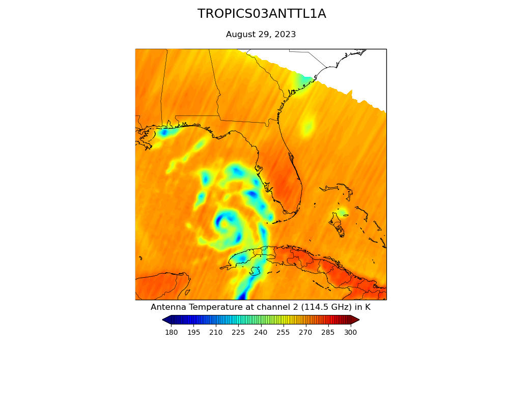
TROPICS05 L1A Orbital Geolocated Native-Resolution Antenna Temperatures V0.2
National Aeronautics and Space Administration —
The "Time-Resolved Observations of Precipitation structure and storm Intensity with a Constellation of Smallsats" (TROPICS) mission has a goal of providing nearly... -
Federal
LRIR/Nimbus-6 Level 2 Inverted Profiles of Temperature and Ozone V001 (LRIRN6L2IPAT) at GES DISC
National Aeronautics and Space Administration —
LRIRN6L2IPAT is the Nimbus-6 Limb Radiance Inversion Radiometer (LRIR) Level 2 Inverted Profiles of Temperature and Ozone data product. The product contains daily... -
Federal
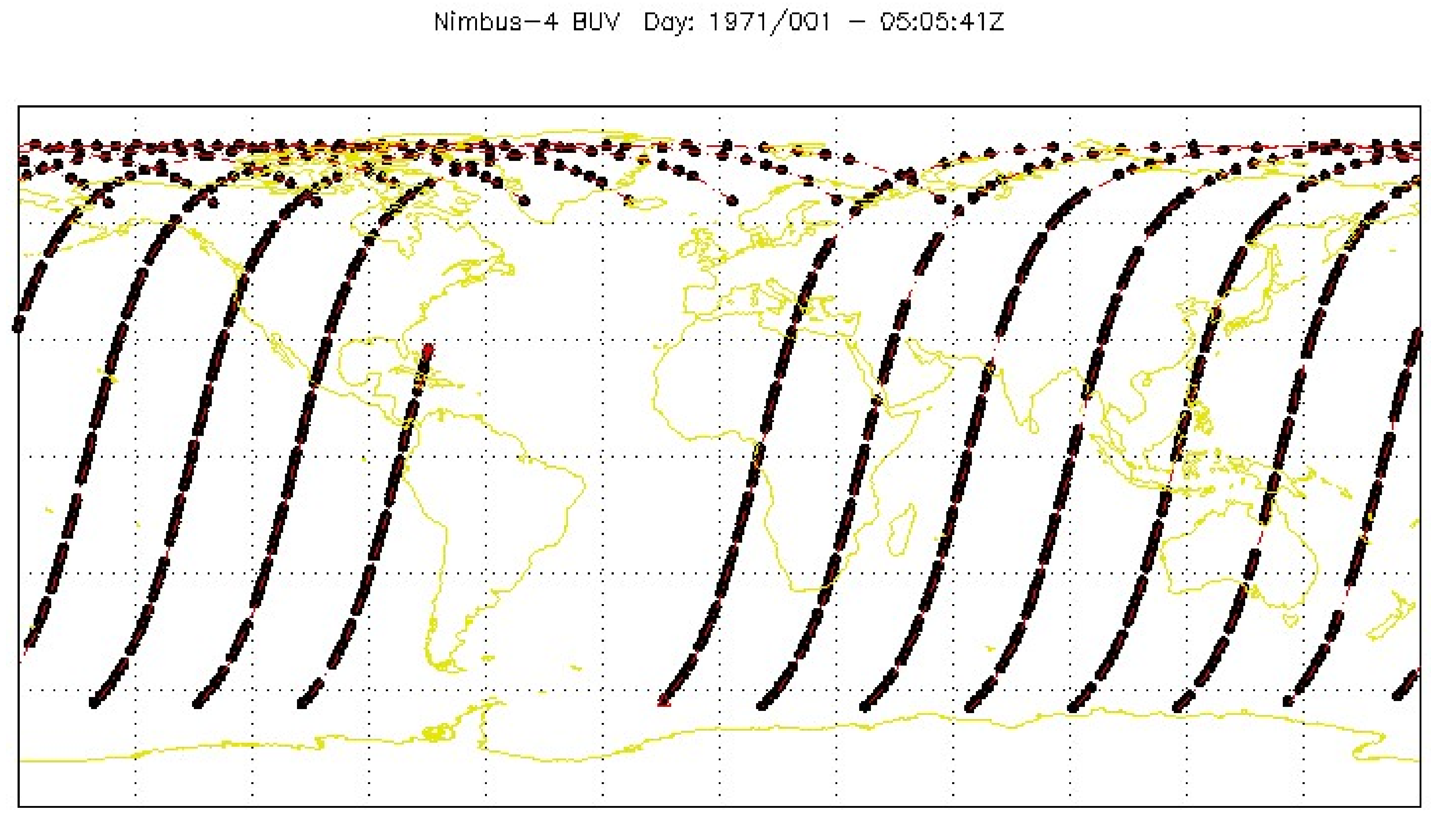
BUV/Nimbus-4 Dark Current Study Working Data V001 (BUVN4L1DCW) at GES DISC
National Aeronautics and Space Administration —
The Nimbus-4 BUV Level-1 Dark Current Study Working Data is derived from the BUV Level 1 Radiance (RUT) product and contains the geophysical indices and... -
Federal
OCO-2 Level 1A collated, parsed, science or calibration data V10 (OCO2_L1aIn_Sample) at GES DISC
National Aeronautics and Space Administration —
Version 10 is the current version of the data set. Older versions will no longer be available and are superseded by Version 10. The Orbiting Carbon Observatory is the... -
Federal
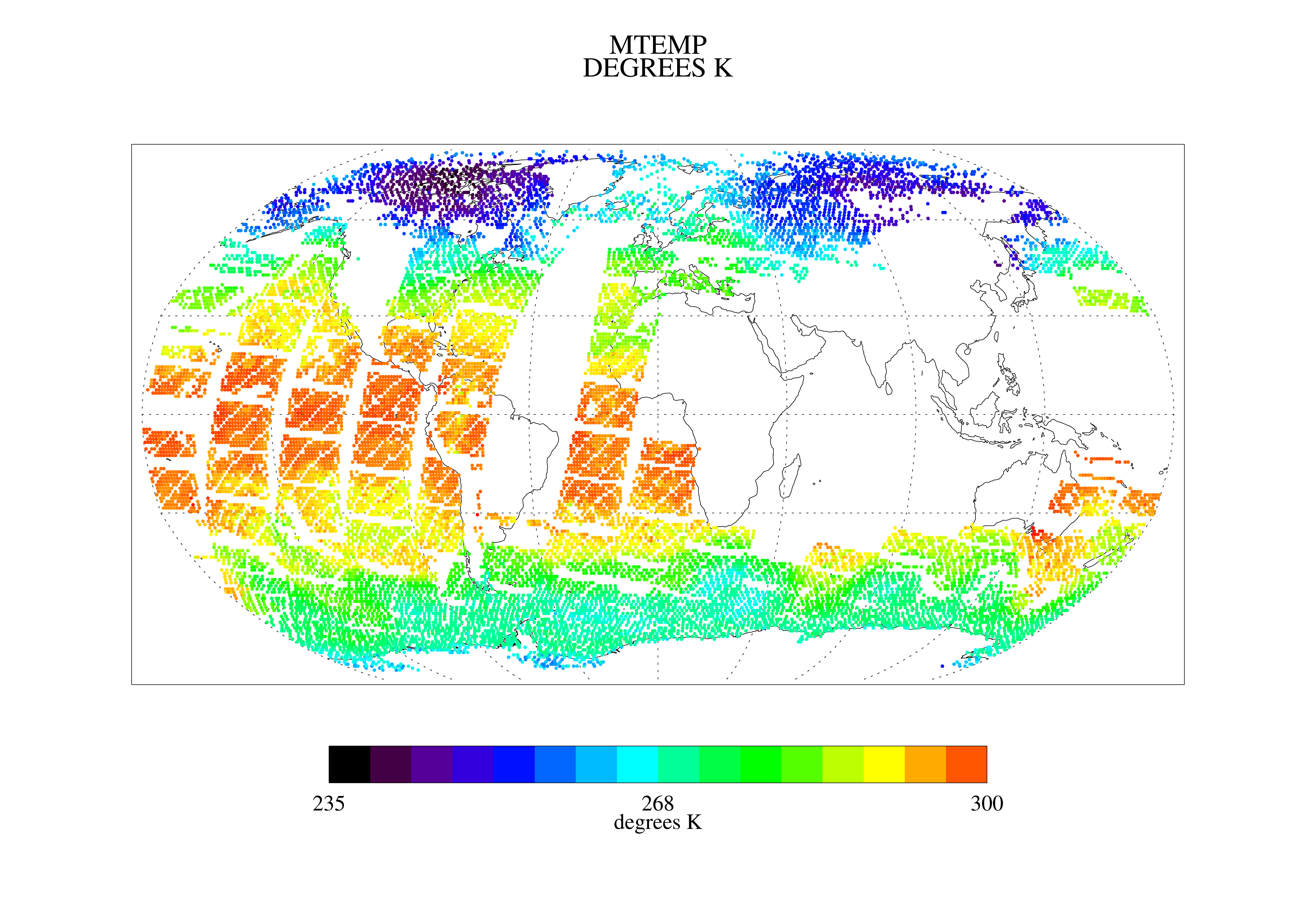
UARS Halogen Occultation Experiment (HALOE) Level 3AT V019 (UARHA3AT) at GES DISC
National Aeronautics and Space Administration —
The Halogen Occultation Experiment (HALOE) Level 3AT data product consists of daily vertical profiles of temperature, aerosol extinction and concentrations of HCl,... -
Federal
SBUV2/NOAA-9 Level 2 Daily Ozone Profile and Total Column from CD-ROM V008 (SBUV2N09O3) at GES DISC
National Aeronautics and Space Administration —
The version 8 SBUV/2 NOAA-9 ozone data were first released at the 2004 Quadrennial Ozone Symposium on DVD. The DVD contained all of the SBUV/2 data from NOAA-9,... -
Federal
TOVS GLA DAILY GRIDS from NOAA-10 V01 (TOVSADNG) at GES DISC
National Aeronautics and Space Administration —
This dataset (TOVSADNG) contains the TIROS Operational Vertical Sounder (TOVS) level 3 geophysical parameters derived using data from NOAA-10 and the physical... -
Federal
TOVS LMD DAILY GRIDS from NOAA-10 V01 (TOVSBDNG) at GES DISC
National Aeronautics and Space Administration —
Level 3 parameters from HIRS/2 and MSU radiances using the Improved Initialization Inversion (3I) classification retrieval scheme by the Laboratoire de Meteorologie... -
Federal
TROPICS01 Pathfinder L2B Instantaneous Surface Rain Rate (ISRR) V1.0
National Aeronautics and Space Administration —
The "Time-Resolved Observations of Precipitation structure and storm Intensity with a Constellation of Smallsats" (TROPICS) mission has a goal of providing nearly... -
Federal
OCO-2 Level 1B calibrated, geolocated calibration spectra, Retrospective Processing V10r (OCO2_L1B_Calibration) at GES DISC
National Aeronautics and Space Administration —
Version 10r is the current version of the data set. Older versions will no longer be available and are superseded by Version 10r. Version 8r is the current version of... -
Federal
AIRS/Aqua L1B Near Real Time (NRT) Infrared (IR) geolocated and calibrated radiances in BUFR format V005 (AIRIBRAD_NRT_BUFR) at GES DISC
National Aeronautics and Space Administration —
WARNING: On 2021/09/23 the EOS Aqua executed a Deep Space Maneuver (DSM). In the DSM, the spacecraft is turned such that the normal Earth field of regard is deep... -
Federal
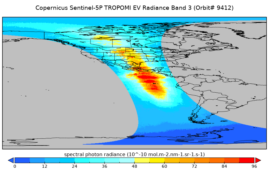
Sentinel-5P TROPOMI Radiance product band 3 (UVIS detector) L1B 5.5km x 3.5km V2 (S5P_L1B_RA_BD3_HiR) at GES DISC
National Aeronautics and Space Administration —
Starting from August 6th in 2019, Sentinel-5P TROPOMI along-track high spatial resolution (~5.5km at nadir) has been implemented. For data before August 6th of 2019,... -
Federal
OCO-2 Level 1A collated, parsed, science or calibration data V11.2 (OCO2_L1aIn_Sample) at GES DISC
National Aeronautics and Space Administration —
Version 11.2 is the current version of the data set. Older versions will no longer be available and are superseded by Version 11.2. The Orbiting Carbon Observatory is... -
Federal
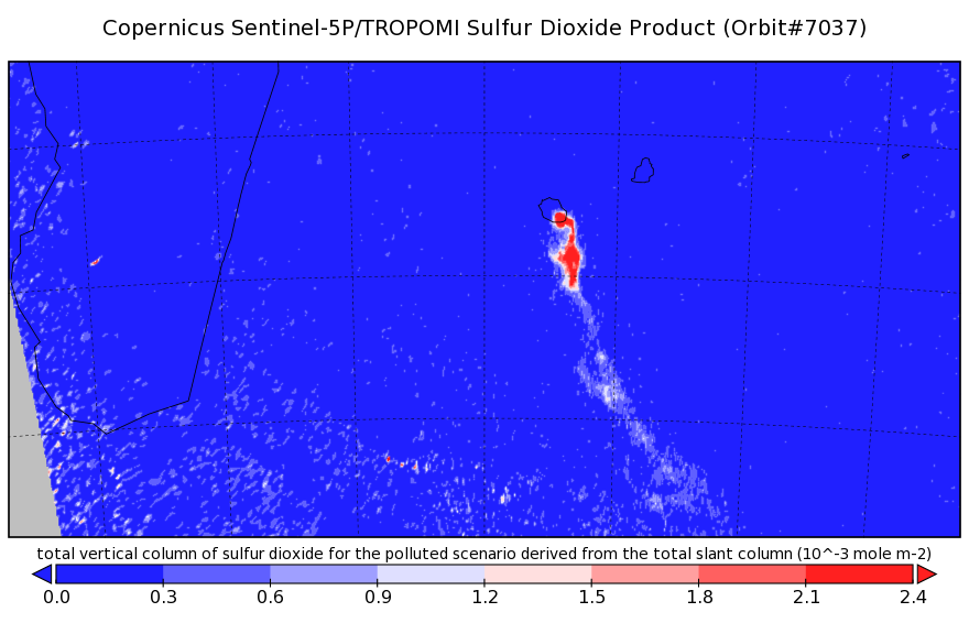
Sentinel-5P TROPOMI Sulphur Dioxide SO2 1-Orbit L2 7km x 3.5km V1 (S5P_L2__SO2___) at GES DISC
National Aeronautics and Space Administration —
Starting from August 6th in 2019, Sentinel-5P TROPOMI along-track high spatial resolution (~5.5km at nadir) has been implemented. Starting from July 13th in 2020,... -
Federal
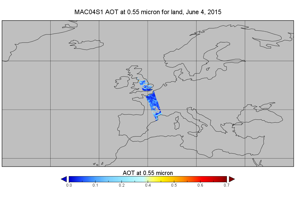
MODIS/Aqua Aerosol 10km 5-Min L2 Wide Swath Subset along CloudSat V002 (MAC04S1) at GES DISC NGDA
National Aeronautics and Space Administration —
This is the wide-swath MODIS/Aqua subset along CloudSat field of view track. The goal of the wide-swath subset is to select and return MODIS data that are within... -
Federal
Sentinel-5P TROPOMI Near-Real-Time (NRT) Carbon Monoxide CO Column 1-Orbit L2 5.5km x 7km V2 (S5P_L2__CO_____HiR_NRT) at GES DISC
National Aeronautics and Space Administration —
The Sentinel-5P TROPOMI Near Real Time (NRT) Carbon Monoxide CO Column 1-Orbit L2 5.5km x 7km V2 (S5P_L2__CO_HiR_NRT) at GES DISC is the near real time version of the... -
Federal
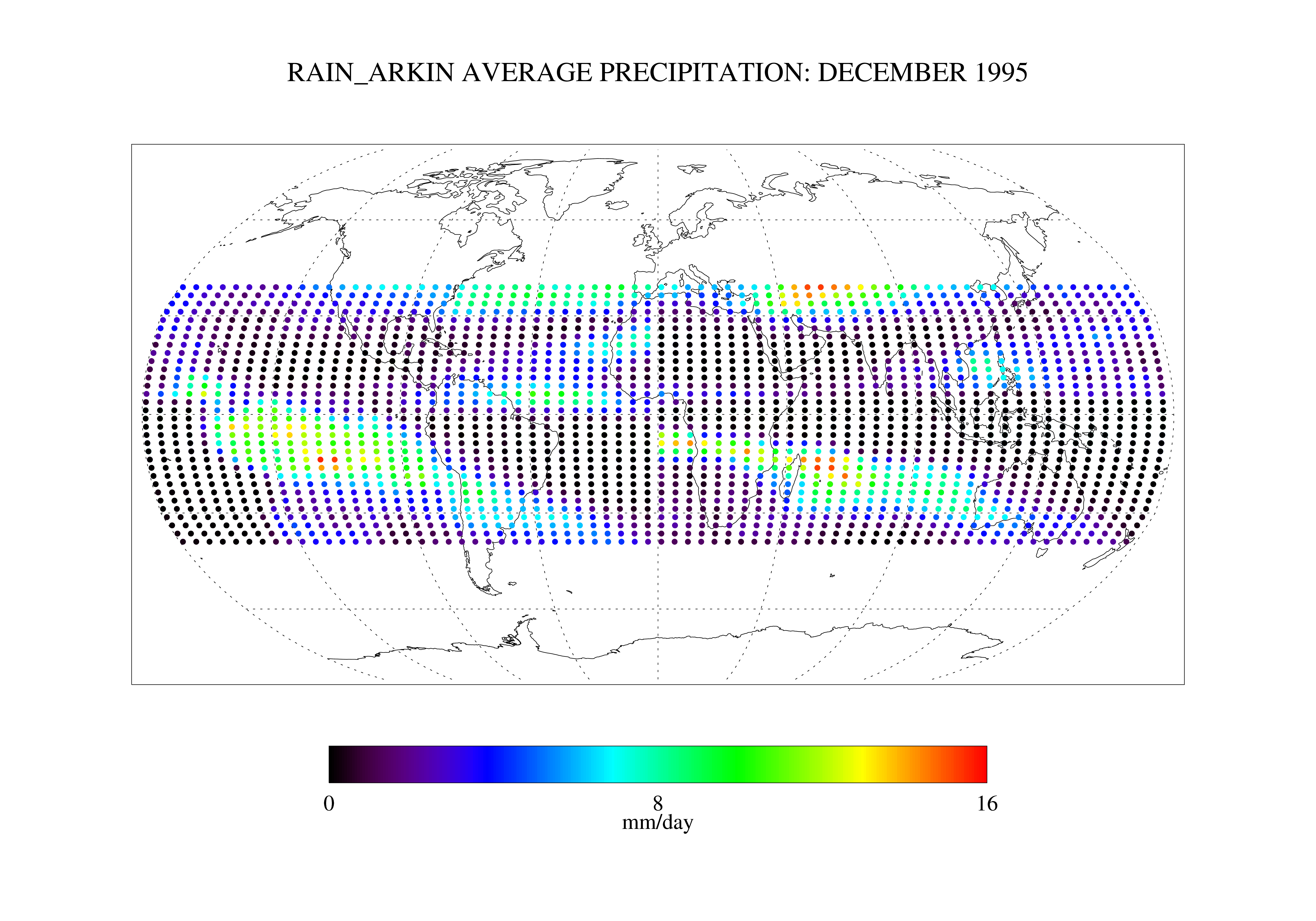
Arkin and Janowiak GPI: IR -Based Monthly Rainfall for the GPCP 2.5 x 2.5 degree V1 (RAIN_ARKIN) at GES DISC
National Aeronautics and Space Administration —
These data are transitioned to a state of permanent preservation. They are available upon request. More advanced datasets have been developed since. One recommended... -
Federal
Sentinel-5P TROPOMI Near-Real-Time (NRT) Radiance product band 3 (UVIS detector) L1B 5.5km x 3.5km V2 (S5P_L1B_RA_BD3_HiR_NRT) at GES DISC
National Aeronautics and Space Administration —
The Sentinel-5P TROPOMI Near Real Time (NRT) Radiance product band 3 (UVIS detector) L1B 5.5km x 21km V2 (S5P_L1B_RA_BD3_HiR_NRT_NRT) product at GES DISC is the near... -
Federal
TROPICS03 Pathfinder L2B Instantaneous Surface Rain Rate (ISRR) V1.0
National Aeronautics and Space Administration —
The "Time-Resolved Observations of Precipitation structure and storm Intensity with a Constellation of Smallsats" (TROPICS) mission has a goal of providing nearly...

Official websites use .gov
A
.gov website belongs to an official government
organization in the United States.
Secure .gov websites use HTTPS
A
lock (
) or https:// means you’ve safely connected to
the .gov website. Share sensitive information only on official,
secure websites.