

53 datasets found
-
Federal
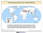
Global Earthquake Total Economic Loss Risk Deciles
National Aeronautics and Space Administration —
The Global Earthquake Total Economic Loss Risk Deciles is a 2.5 minute grid of global earthquake total economic loss risks. A process of spatially allocating Gross... -
Federal
BLM AK Areas of Critical Environmental Concern
Department of the Interior —
In general, the ACEC dataset defines areas within the public lands where special management attention is required to protect and prevent irreparable damage to... -
Federal
Global High Resolution Daily Extreme Urban Heat Exposure (UHE-Daily), 1983-2016
National Aeronautics and Space Administration —
The Global High Resolution Daily Extreme Urban Heat Exposure (UHE-Daily), 1983-2016 data set contains a high-resolution, longitudinal global record of geolocated... -
Federal
Global Landslide Mortality Risks and Distribution
National Aeronautics and Space Administration —
The Global Landslide Mortality Risks and Distribution is a 2.5 minute grid of global landslide mortality risks. Gridded Population of the World, Version 3 (GPWv3)... -
Federal
Global Earthquake Proportional Economic Loss Risk Deciles
National Aeronautics and Space Administration —
The Global Earthquake Proportional Economic Loss Risk Deciles is a 2.5 minute grid of earthquake hazard economic loss as proportions of Gross Domestic Product (GDP)... -
Federal
Global Drought Proportional Economic Loss Risk Deciles
National Aeronautics and Space Administration —
The Global Drought Proportional Economic Loss Risk Deciles is a 2.5 minute grid of drought hazard economic loss as proportions of Gross Domestic Product (GDP) per... -
Federal
NaHRSI Scored Results
U.S. Environmental Protection Agency —
Domains, Indicators and Metrics of NaHRSI and CRSI. This dataset is associated with the following publication: Summers, K., L. Harwell, K. Buck, L. Smith, J. Harvey,... -
Federal
BLM NM Areas of Critical Environmental Concern
Department of the Interior —
This polygon feature class shows the spatial extent and boundaries of Areas of Critical Environmental Concern that have become officially designated by the BLM. These... -
Federal
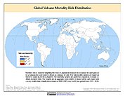
Global Volcano Hazard Frequency and Distribution
National Aeronautics and Space Administration —
Global Volcano Hazard Frequency and Distribution is a 2.5 minute gridded data set based upon the National Geophysical Data Center (NGDC) Volcano Database spanning the... -
Federal
Global Landslide Proportional Economic Loss Risk Deciles
National Aeronautics and Space Administration —
The Global Landslide Proportional Economic Loss Risk Deciles is a 2.5 minute grid of landslide hazard economic loss as proportions of Gross Domestic Product (GDP) per... -
Federal
Household survey data about participation in wildfire risk mitigation cost-share in western Colorado 2013-2017
Department of the Interior —
Household survey data about participation in wildfire risk mitigation cost-share programs and related questions, including stated barriers to conducting wildfire risk... -
Federal
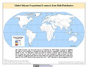
Global Volcano Proportional Economic Loss Risk Deciles
National Aeronautics and Space Administration —
Global Volcano Proportional Economic Loss Risk Deciles is a 2.5 minute grid of volcano hazard economic loss as proportions of Gross Domestic Product (GDP) per... -
Federal
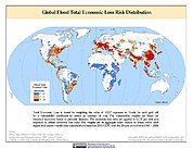
Global Flood Proportional Economic Loss Risk Deciles
National Aeronautics and Space Administration —
The Global Flood Proportional Economic Loss Risk Deciles is a 2.5 minute grid of flood hazard economic loss as proportions of Gross Domestic Product (GDP) per... -
Federal
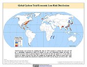
Global Cyclone Total Economic Loss Risk Deciles
National Aeronautics and Space Administration —
The Global Cyclone Total Economic Loss Risk Deciles is a 2.5 minute grid of global cyclone total economic loss risks. A process of spatially allocating Gross Domestic... -
Federal
BLM UT Designated Areas of Critical Environmental Concern (Polygon)
Department of the Interior —
The layers within this feature service show the spatial extent and boundaries of Areas of Critical Environmental Concern (ACECs) in Utah that have become officially... -
Federal
Intersection of Natural Hazard Vulnerability and RCRA Site Location
U.S. Environmental Protection Agency —
Co-occurrence of natural hazard exposures and RCRA site locations at the county level where natural hazards are in the top quartile of exposures. This dataset is...
53 datasets found