

53 datasets found
-
Federal
Global Flood Hazard Frequency and Distribution
National Aeronautics and Space Administration —
The Global Flood Hazard Frequency and Distribution is a 2.5 minute grid derived from a global listing of extreme flood events between 1985 and 2003 (poor or missing... -
Federal
Climiate Resilience Screening Index and Domain Scores
U.S. Environmental Protection Agency —
CRSI and related-___domain scores for all 50 states and 3135 counties in the U.S. This dataset is not publicly accessible because: They are already available within the... -
Federal
Global Earthquake Hazard Distribution - Peak Ground Acceleration
National Aeronautics and Space Administration —
The Global Earthquake Hazard Distribution - Peak Ground Acceleration is a 2.5 minute grid of global earthquake hazards developed using Global Seismic Hazard Program... -
Federal
Geocoded Disasters (GDIS) Dataset
National Aeronautics and Space Administration —
The Geocoded Disasters (GDIS) Dataset is a geocoded extension of a selection of natural disasters from the Centre for Research on the Epidemiology of Disasters'... -
Federal
BLM Natl Historic Areas of Critical Environmental Concern
Department of the Interior —
This dataset represents the BLM Historical Areas of Critical Environmental Concern polygon feature class. The BLM Historical Areas of Critical Environmental Concern... -
Federal
Intersection of Natural Hazard Vulnerability and Superfund Site Location
U.S. Environmental Protection Agency —
Spreadsheet lists all active and upcoming Superfund sites and their vulnerability to 12 natural hazards using a vulnerability score between 0 and 100. This dataset is... -
Federal
NASA Earth Observatory Images
National Aeronautics and Space Administration —
The Earth Observatory is part of the EOS Project Science Office located at NASA Goddard Space Flight Center. -
Federal
BLM Natl Areas of Critical Environmental Concern
Department of the Interior —
This polygon feature class contains BLM Designated Areas of Critical Environmental Concern (ACECs) polygons. These define areas within the public lands where special... -
Federal
Annual Global High-Resolution Extreme Heat Estimates (GEHE), 1983-2016
National Aeronautics and Space Administration —
The Annual Global High-Resolution Extreme Heat Estimates (GEHE), 1983-2016 data set provides global 0.05 degrees (~5 km) gridded annual counts of the number of days... -
Federal
BLM NV ACEC Designated Polygons
Department of the Interior —
This polygon feature class shows the spatial extent and boundaries of Areas of Critical Environmental Concern that have become officially designated by the BLM... -
Federal
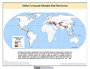
Global Earthquake Mortality Risks and Distribution
National Aeronautics and Space Administration —
The Global Earthquake Mortality Risks and Distribution is a 2.5 minute grid of global earthquake mortality risks. Gridded Population of the World, Version 3 (GPWv3)... -
Federal
Climate History Extensions
U.S. Environmental Protection Agency —
This feature class contains yearly (2000-2019) natural hazard exposure estimates (percent area) at the county-level for the entire US (including AK, HI, and PR).... -
Federal
Distribution of large boulders on the deposit of the West Salt Creek rock avalanche, western Colorado
Department of the Interior —
On May 25th, 2014, a 54.5 Mm3 rock avalanche occurred in the West Salt Creek valley in western Colorado following heavy rainfall on top of snow (Coe and others,...
53 datasets found