
-
Federal
H06829: NOS Hydrographic Survey , 1947-07-22
National Oceanic and Atmospheric Administration, Department of Commerce —
The National Oceanic and Atmospheric Administration (NOAA) has the statutory mandate to collect hydrographic data in support of nautical chart compilation for safe... -
Federal
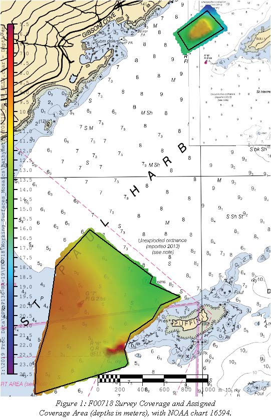
F00718: NOS Hydrographic Survey , 2019-06-20
National Oceanic and Atmospheric Administration, Department of Commerce —
The National Oceanic and Atmospheric Administration (NOAA) has the statutory mandate to collect hydrographic data in support of nautical chart compilation for safe... -
Federal
Port Lions, Alaska 8/15 arc-second MHHW Coastal Digital Elevation Model
National Oceanic and Atmospheric Administration, Department of Commerce —
NOAA's National Centers for Environmental Information is building high-resolution digital elevation models (DEMs) to support individual coastal States as part of the... -
Federal
Shoreline Mapping Program of KODIAK ISLAND, CAPE IZHUT TO CAPE UGAT, AK, AK0603D NGDA
National Oceanic and Atmospheric Administration, Department of Commerce —
These data provide an accurate high-resolution shoreline compiled from imagery of KODIAK ISLAND, CAPE IZHUT TO CAPE UGAT, AK . This vector shoreline data is based on... -
Federal
Ouzinkie, Alaska 8/15 arc-second MHHW Coastal Digital Elevation Model
National Oceanic and Atmospheric Administration, Department of Commerce —
NOAA's National Centers for Environmental Information is building high-resolution digital elevation models (DEMs) to support individual coastal States as part of the... -
Federal
Kodiak, Alaska 1/3 arc-second MHW Coastal Digital Elevation Model
National Oceanic and Atmospheric Administration, Department of Commerce —
NOAA's National Geophysical Data Center (NGDC) is building high-resolution digital elevation models (DEMs) for select U.S. coastal regions. These integrated... -
Federal
AFSC/ABL: Karluk sockeye salmon scale time series
National Oceanic and Atmospheric Administration, Department of Commerce —
To better understand how density-dependent growth of ocean-dwelling Pacific salmon varied with climate and population dynamics, we examined the marine growth of... -
Federal
AFSC/RACE/SAP/Foy: Seawater chemistry of three pH treatments used to test the effect of pH on Tanner crab biology: Kodiak Island, Alaska.
National Oceanic and Atmospheric Administration, Department of Commerce —
To study the effects of ocean acidification we examined the effects of ocean acidification on the embryo and larval stages of the economically important southern... -
Federal
Shoreline Mapping Program of KODIAK ISLAND, SITKALIDAK STRAIT TO UGAK ISLAND, AK, AK0603B NGDA
National Oceanic and Atmospheric Administration, Department of Commerce —
These data provide an accurate high-resolution shoreline compiled from imagery of KODIAK ISLAND, SITKALIDAK STRAIT TO UGAK ISLAND, AK . This vector shoreline data is... -
Federal
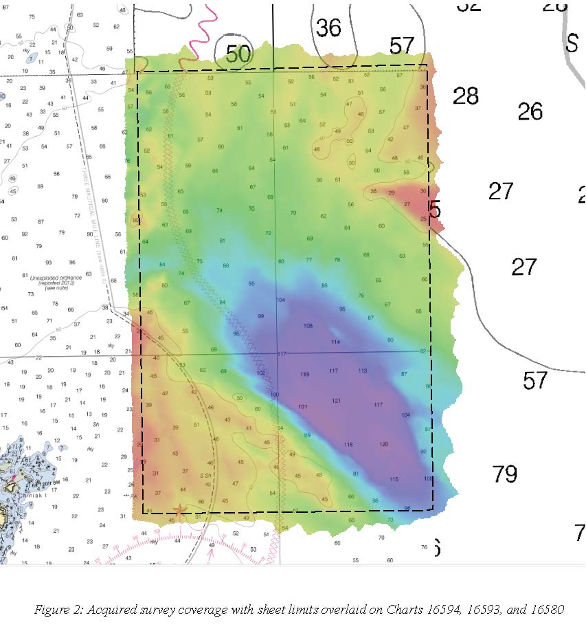
H13105: NOS Hydrographic Survey , 2019-06-20
National Oceanic and Atmospheric Administration, Department of Commerce —
The National Oceanic and Atmospheric Administration (NOAA) has the statutory mandate to collect hydrographic data in support of nautical chart compilation for safe... -
Federal
H12318: NOS Hydrographic Survey , North Coast of Kodiak Island, 2012-09-19
National Oceanic and Atmospheric Administration, Department of Commerce —
The National Oceanic and Atmospheric Administration (NOAA) has the statutory mandate to collect hydrographic data in support of nautical chart compilation for safe... -
Federal
H13002: NOS Hydrographic Survey , 2017-06-12
National Oceanic and Atmospheric Administration, Department of Commerce —
The National Oceanic and Atmospheric Administration (NOAA) has the statutory mandate to collect hydrographic data in support of nautical chart compilation for safe... -
Federal
H12317: NOS Hydrographic Survey , 2011-06-30
National Oceanic and Atmospheric Administration, Department of Commerce —
The National Oceanic and Atmospheric Administration (NOAA) has the statutory mandate to collect hydrographic data in support of nautical chart compilation for safe... -
Federal
H12999: NOS Hydrographic Survey , 2017-06-30
National Oceanic and Atmospheric Administration, Department of Commerce —
The National Oceanic and Atmospheric Administration (NOAA) has the statutory mandate to collect hydrographic data in support of nautical chart compilation for safe... -
Federal
H12996: NOS Hydrographic Survey , 2017-07-02
National Oceanic and Atmospheric Administration, Department of Commerce —
The National Oceanic and Atmospheric Administration (NOAA) has the statutory mandate to collect hydrographic data in support of nautical chart compilation for safe... -
Federal
H13106: NOS Hydrographic Survey , 2019-06-20
National Oceanic and Atmospheric Administration, Department of Commerce —
The National Oceanic and Atmospheric Administration (NOAA) has the statutory mandate to collect hydrographic data in support of nautical chart compilation for safe... -
Federal
H05441: NOS Hydrographic Survey , 1933-01-01
National Oceanic and Atmospheric Administration, Department of Commerce —
The National Oceanic and Atmospheric Administration (NOAA) has the statutory mandate to collect hydrographic data in support of nautical chart compilation for safe... -
Federal
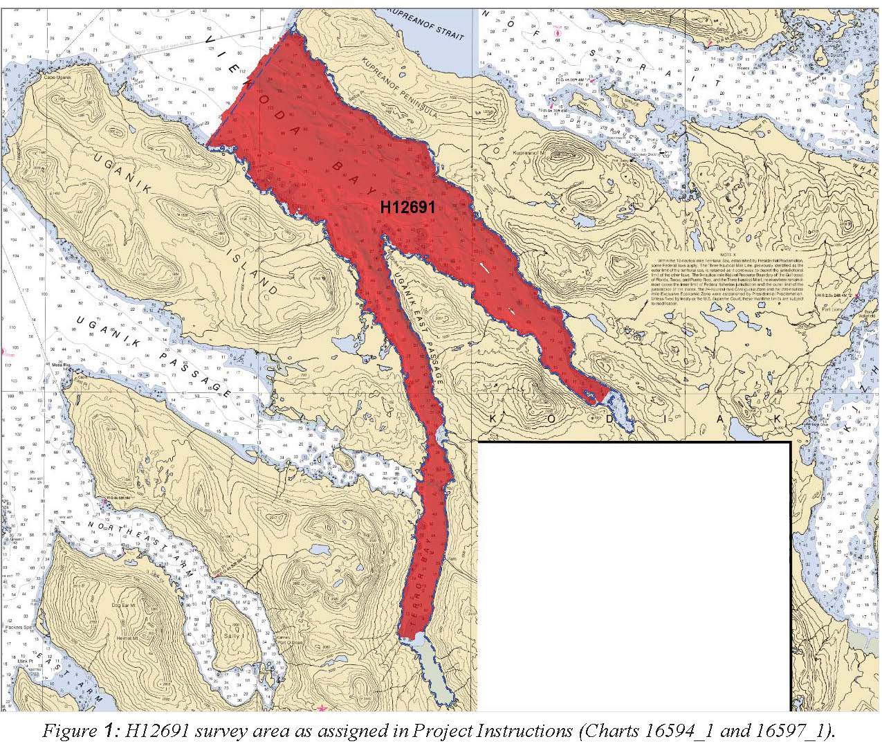
H12691: NOS Hydrographic Survey , 2015-10-21
National Oceanic and Atmospheric Administration, Department of Commerce —
The National Oceanic and Atmospheric Administration (NOAA) has the statutory mandate to collect hydrographic data in support of nautical chart compilation for safe... -
Federal
AFSC/RACE/FBEP/Ryer: Depth distribution, habitat associations, and differential growth of newly settled southern Tanner crab (Chionoecetes bairdi) in embayments around Kodiak Island, Alaska
National Oceanic and Atmospheric Administration, Department of Commerce —
This dataset is from field surveys that examined depth distribution, habitat association, and growth of newly settled Tanner crab at 4 sites around the eastern end of... -
Federal
Obsolete - AFSC/RACE/EcoFOCI: 2011 GOA-IERP & Seward Line 1TX11
National Oceanic and Atmospheric Administration, Department of Commerce —
1.Conduct tandem 20 cm (153 mesh size) and 60 cm (505 mesh size) Bongo net tows at all grid stations (Table 2) working from west to east. Deployments were made aft...

Official websites use .gov
A
.gov website belongs to an official government
organization in the United States.
Secure .gov websites use HTTPS
A
lock (
) or https:// means you’ve safely connected to
the .gov website. Share sensitive information only on official,
secure websites.
.jpg)