
-
State
Updated tsunami inundation maps of the Kodiak area, Alaska
State of Alaska —
Staff from Alaska Earthquake Center, Geophysical Institute and Alaska Division of Geological & Geophysical Surveys evaluated potential potential tsunami hazard... -
Federal
H06829: NOS Hydrographic Survey , 1947-07-22
National Oceanic and Atmospheric Administration, Department of Commerce —
The National Oceanic and Atmospheric Administration (NOAA) has the statutory mandate to collect hydrographic data in support of nautical chart compilation for safe... -
Federal
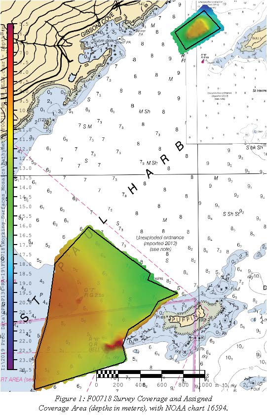
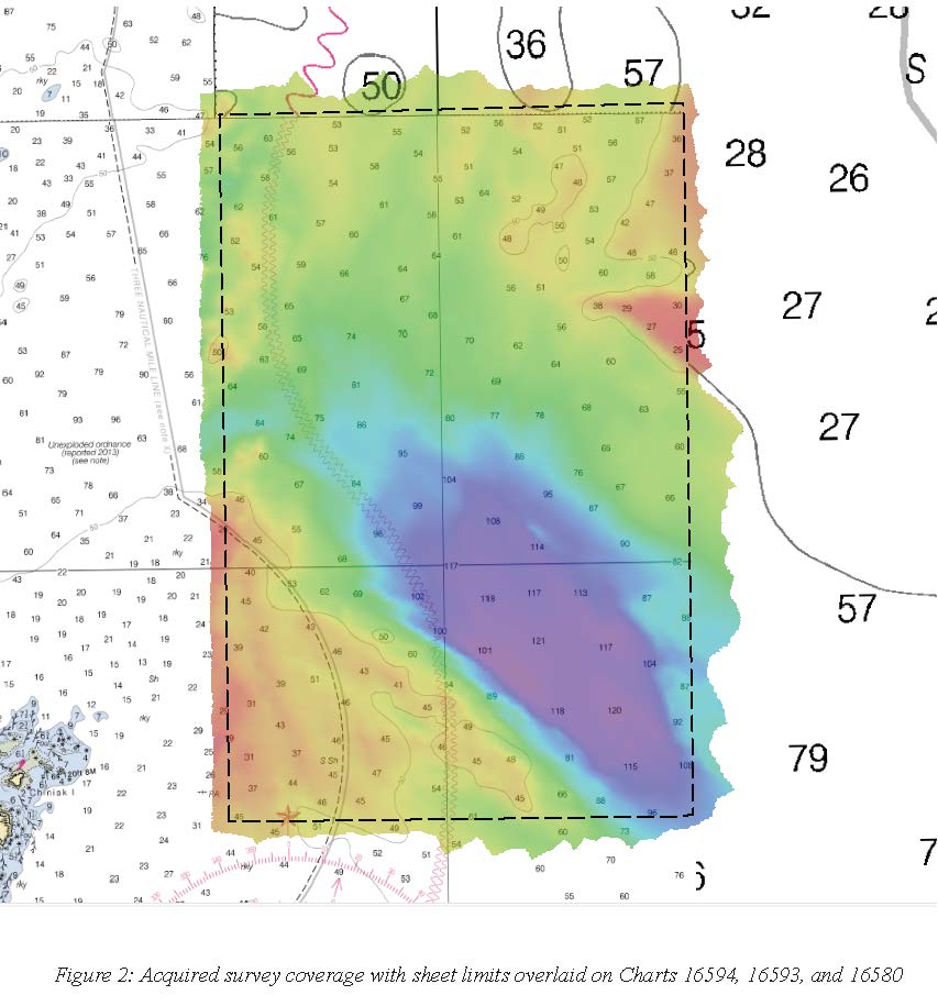
F00718: NOS Hydrographic Survey , 2019-06-20
National Oceanic and Atmospheric Administration, Department of Commerce —
The National Oceanic and Atmospheric Administration (NOAA) has the statutory mandate to collect hydrographic data in support of nautical chart compilation for safe... -
Federal
Port Lions, Alaska 8/15 arc-second MHHW Coastal Digital Elevation Model
National Oceanic and Atmospheric Administration, Department of Commerce —
NOAA's National Centers for Environmental Information is building high-resolution digital elevation models (DEMs) to support individual coastal States as part of the... -
Federal
Shoreline Mapping Program of KODIAK ISLAND, CAPE IZHUT TO CAPE UGAT, AK, AK0603D NGDA
National Oceanic and Atmospheric Administration, Department of Commerce —
These data provide an accurate high-resolution shoreline compiled from imagery of KODIAK ISLAND, CAPE IZHUT TO CAPE UGAT, AK . This vector shoreline data is based on... -
Federal
Ouzinkie, Alaska 8/15 arc-second MHHW Coastal Digital Elevation Model
National Oceanic and Atmospheric Administration, Department of Commerce —
NOAA's National Centers for Environmental Information is building high-resolution digital elevation models (DEMs) to support individual coastal States as part of the... -
Federal
Kodiak, Alaska 1/3 arc-second MHW Coastal Digital Elevation Model
National Oceanic and Atmospheric Administration, Department of Commerce —
NOAA's National Geophysical Data Center (NGDC) is building high-resolution digital elevation models (DEMs) for select U.S. coastal regions. These integrated... -
Federal
Kodiak, Alaska Tsunami Forecast Grids for MOST Model
National Oceanic and Atmospheric Administration, Department of Commerce —
The Kodiak, Alaska Forecast Model Grids provides bathymetric data strictly for tsunami inundation modeling with the Method of Splitting Tsunami (MOST) model. MOST is... -
Federal
AFSC/ABL: Karluk sockeye salmon scale time series
National Oceanic and Atmospheric Administration, Department of Commerce —
To better understand how density-dependent growth of ocean-dwelling Pacific salmon varied with climate and population dynamics, we examined the marine growth of... -
Federal
AFSC/RACE/SAP/Foy: Seawater chemistry of three pH treatments used to test the effect of pH on Tanner crab biology: Kodiak Island, Alaska.
National Oceanic and Atmospheric Administration, Department of Commerce —
To study the effects of ocean acidification we examined the effects of ocean acidification on the embryo and larval stages of the economically important southern... -
State
Tsunami inundation maps for Karluk and Larsen Bay, Kodiak Island, Alaska
State of Alaska —
Tsunami inundation maps for Karluk and Larsen Bay, Kodiak Island, Alaska, Report of Investigation 2022-2, identifies potential tsunami hazards for the Kodiak Island... -
State
Regional tsunami hazard assessment for selected communities on Kodiak Island, Alaska
State of Alaska —
We assess potential tsunami hazard for the following seven coastal communities on Kodiak Island, Alaska: Akhiok, Chiniak, Karluk, Larsen Bay, Old Harbor, Ouzinkie,... -
Federal
Shoreline Mapping Program of KODIAK ISLAND, SITKALIDAK STRAIT TO UGAK ISLAND, AK, AK0603B NGDA
National Oceanic and Atmospheric Administration, Department of Commerce —
These data provide an accurate high-resolution shoreline compiled from imagery of KODIAK ISLAND, SITKALIDAK STRAIT TO UGAK ISLAND, AK . This vector shoreline data is... -
Federal
H13105: NOS Hydrographic Survey , 2019-06-20
National Oceanic and Atmospheric Administration, Department of Commerce —
The National Oceanic and Atmospheric Administration (NOAA) has the statutory mandate to collect hydrographic data in support of nautical chart compilation for safe... -
Federal
H12318: NOS Hydrographic Survey , North Coast of Kodiak Island, 2012-09-19
National Oceanic and Atmospheric Administration, Department of Commerce —
The National Oceanic and Atmospheric Administration (NOAA) has the statutory mandate to collect hydrographic data in support of nautical chart compilation for safe... -
Federal
H13002: NOS Hydrographic Survey , 2017-06-12
National Oceanic and Atmospheric Administration, Department of Commerce —
The National Oceanic and Atmospheric Administration (NOAA) has the statutory mandate to collect hydrographic data in support of nautical chart compilation for safe... -
Federal
H12317: NOS Hydrographic Survey , 2011-06-30
National Oceanic and Atmospheric Administration, Department of Commerce —
The National Oceanic and Atmospheric Administration (NOAA) has the statutory mandate to collect hydrographic data in support of nautical chart compilation for safe... -
Federal
H12999: NOS Hydrographic Survey , 2017-06-30
National Oceanic and Atmospheric Administration, Department of Commerce —
The National Oceanic and Atmospheric Administration (NOAA) has the statutory mandate to collect hydrographic data in support of nautical chart compilation for safe... -
Federal
H12996: NOS Hydrographic Survey , 2017-07-02
National Oceanic and Atmospheric Administration, Department of Commerce —
The National Oceanic and Atmospheric Administration (NOAA) has the statutory mandate to collect hydrographic data in support of nautical chart compilation for safe... -
Federal
H13106: NOS Hydrographic Survey , 2019-06-20
National Oceanic and Atmospheric Administration, Department of Commerce —
The National Oceanic and Atmospheric Administration (NOAA) has the statutory mandate to collect hydrographic data in support of nautical chart compilation for safe...

Official websites use .gov
A
.gov website belongs to an official government
organization in the United States.
Secure .gov websites use HTTPS
A
lock (
) or https:// means you’ve safely connected to
the .gov website. Share sensitive information only on official,
secure websites.
.jpg)