
-
Federal
CRED 20 m Gridded bathymetry of Pioneer Bank, Hawaii, USA (Arc ASCII format)
National Oceanic and Atmospheric Administration, Department of Commerce —
Gridded bathymetry of the shelf and slope environments of Pioneer Bank, Hawaii, USA. Bottom coverage was achieved in depths between 20 and 1000 meters. The ASCII... -
Federal
CRED Simrad em300 multibeam backscatter data from portions of the banktop and bank edge environments at Maro Reef, Hawaii, USA with 5 meter resolution in netCDF format
National Oceanic and Atmospheric Administration, Department of Commerce —
Multibeam backscatter imagery extracted from gridded bathymetry of Maro Reef, Northwestern Hawaiian Islands, USA. These data provide coverage between 20 and 5000... -
Federal
CRED Gridded Bathymetry of Bank 66 and east French Frigate Shoals (100-020) in the Northwestern Hawaiian Islands
National Oceanic and Atmospheric Administration, Department of Commerce —
File 100-020b is a 60-m ASCII grid of depth data collected near Bank 66, East French Frigate Shoals in the Northwestern Hawaiian Islands as of May 2003. This grid has... -
Federal
Simrad EM300 multibeam backscatter data from portions of the banktop and bank edge environments at Kure Atoll, Hawaii, USA
National Oceanic and Atmospheric Administration, Department of Commerce —
Multibeam backscatter imagery extracted from gridded bathymetry of Kure Atoll, Northwestern Hawaiian Islands, USA. These data provide coverage between 0 and 2000... -
Federal
2005 EM300 and EM3002D Multibeam Sonar Data from Cruise Hi'ialakai HI-05-08 - Northwestern Hawaiian Islands
National Oceanic and Atmospheric Administration, Department of Commerce —
EM300 and EM3002D multibeam Data were collected from 11-31 October 2005 aboard NOAA Ship Hi'ialakai at Maro Reef and a seamount east of Nihoa Island in the... -
Federal
CRED 20 m Gridded bathymetry and IKONOS estimated depths of Lisianski Island, Hawaii, USA (Arc ASCII format)
National Oceanic and Atmospheric Administration, Department of Commerce —
Gridded bathymetry and IKONOS estimated depths of the shelf and slope environments of Lisianski Island, Northwestern Hawaiian Islands, Hawaii, USA. Bottom coverage... -
Federal
CRED Gridded Bathymetry near Northampton Seamounts to West Laysan Island (100-005) Northwestern Hawaiian Islands
National Oceanic and Atmospheric Administration, Department of Commerce —
File 100-005b is a 60-m ASCII grid of depth data collected near Kure Atoll in the Northwestern Hawaiian Islands as of May 2003. This grid has been produced as part of... -
Federal
CRED Cumulative Map of Percent Scleractinian Coral Cover at Gardner Pinnacles, 2003
National Oceanic and Atmospheric Administration, Department of Commerce —
This map displays optical validation observation locations and percent coverage of scleractinian coral overlaid on bathymetry. -
Federal
CRED Reson 8101 multibeam backscatter data from portions of the banktop and bank edge environments at Maro Reef, Hawaii, USA with 30 meter resolution in GeoTIFF format
National Oceanic and Atmospheric Administration, Department of Commerce —
Multibeam backscatter imagery extracted from gridded bathymetry of Maro Reef, Northwestern Hawaiian Islands, USA. These data provide coverage between 20 and 5000... -
Federal
2005 Reson 8101ER Multibeam Sonar Data from Cruise AHI-05-08 - Northwestern Hawaiian Islands
National Oceanic and Atmospheric Administration, Department of Commerce —
Reson 8101ER multibeam Data were collected from 11-31 October 2006 aboard NOAA Survey Launch Acoustic Habitat Investigator (AHI) at at Maro Reef in the Northwestern... -
Federal
CRED 20 m Gridded bathymetry of Pioneer Bank, Hawaii, USA (NetCDF format)
National Oceanic and Atmospheric Administration, Department of Commerce —
Gridded bathymetry of the shelf and slope environments of Pioneer Bank, Hawaii, USA. Bottom coverage was achieved in depths between 20 and 1000 meters. The netCDF... -
Federal
CRED 5 m Gridded bathymetry of Brooks Banks, Hawaii, USA (Arc ASCII format)
National Oceanic and Atmospheric Administration, Department of Commerce —
Gridded bathymetry (5m) of the shelf and slope environments of Brooks Banks, Hawaii, USA. The ASCII includes multibeam bathymetry from the Simrad EM300, Simrad... -
Federal
CRED 20m Gridded bathymetry and IKONOS estimated depths of Maro Reef, Hawaii, USA (Arc ASCII format)
National Oceanic and Atmospheric Administration, Department of Commerce —
Gridded bathymetry and IKONOS estimated depths of the shelf and slope environments of Maro Reef, Hawaii, USA. Bottom coverage was achieved in depths between 0 and... -
Federal
CRED 20 m Gridded bathymetry of Gardner Pinnacles, Hawaii, USA (Arc ASCII format)
National Oceanic and Atmospheric Administration, Department of Commerce —
Gridded bathymetry (20m) of the shelf and slope environments of Gardner Pinnacles, Northwestern Hawaiian Islands, Hawaii, USA. This ASCII includes multibeam... -
Federal
CRED Cumulative Map of Percent Scleractinian Coral Cover at French Frigate Shoals
National Oceanic and Atmospheric Administration, Department of Commerce —
This map displays optical validation observation locations and percent coverage of scleractinian coral overlaid on bathymetry. -
Federal
2006 EM300 Multibeam Sonar Data from Cruise Hi'ialakai HI-06-12 - Northwestern Hawaiian Islands
National Oceanic and Atmospheric Administration, Department of Commerce —
EM300 and EM3002D multibeam data were collected between 10-29 October 2006 aboard NOAA Ship Hi'ialakai at Brooks Banks, St. Rogatien Bank, and West Nihoa Island in... -
Federal
CRED 20 m Gridded bathymetry of Twin Banks, Northwestern Hawaiian Islands, USA (NetCDF format)
National Oceanic and Atmospheric Administration, Department of Commerce —
Gridded bathymetry (20m) of the shelf and slope environments of Twin Banks, Hawaii, USA. Bottom coverage was achieved in depths between 61 and 1500 meters. The netCDF... -
Federal
CRED Gridded Bathymetry near South Maro Reef (100-008), Northwestern Hawaiian Islands
National Oceanic and Atmospheric Administration, Department of Commerce —
File 100-008b is a 60-m ASCII grid of depth data collected near south Maro Reef in the Northwestern Hawaiian Islands as of May 2003. This grid has been produced as... -
Federal
CRED Gridded 20m bathymetry and IKONOS estimated depths of Midway Atoll, Hawaii, USA (Arc ASCII format)
National Oceanic and Atmospheric Administration, Department of Commerce —
Gridded bathymetry and IKONOS estimated depths of the shelf and slope environments of Midway Atoll, Hawaii, USA. Bottom coverage was achieved in depths between 0 and... -
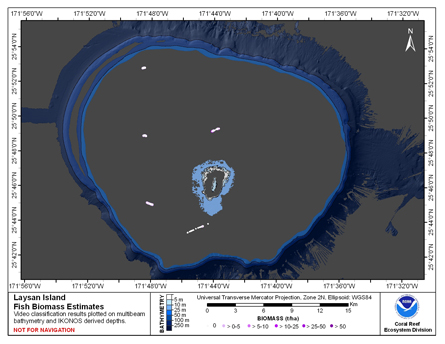
Federal
CRED Fish Biomass Estimates map at Laysan Island
National Oceanic and Atmospheric Administration, Department of Commerce —
This map displays fish biomass observation locations overlaid on bathymetry

Official websites use .gov
A
.gov website belongs to an official government
organization in the United States.
Secure .gov websites use HTTPS
A
lock (
) or https:// means you’ve safely connected to
the .gov website. Share sensitive information only on official,
secure websites.