
-
Federal
Sea level measured by tide gauges from global oceans as part of the Joint Archive for Sea Level (JASL) since 1846
National Oceanic and Atmospheric Administration, Department of Commerce —
This collection contains the complete holdings of the Joint Archive for Sea Level (JASL) for hourly and daily data that have been quality controlled, assessed, and... -
Federal
2018 Mean High Water Shorelines of the Puerto Rico coast used in Shoreline Change Analysis
Department of the Interior —
The U.S. Geological Survey (USGS) maintains shoreline positions for the United States coasts from both older sources, such as aerial photos or topographic surveys, as... -
Federal
Projected flooding extents and depths based on 10-, 50-, 100-, and 500-year wave-energy return periods, with and without coral reefs, for the States of Hawaii and Florida, the Territories of Guam, American Samoa, Puerto Rico, and the U.S. Virgin Islands, and the Commonwealth of the Northern Mariana Islands
Department of the Interior —
This data release provides flooding extent polygons (flood masks) and depth values (flood points) based on wave-driven total water levels for 22 locations within the... -
Federal
Projected flooding extents and depths based on 10-, 50-, 100-, and 500-year wave-energy return periods for the Commonwealth of Puerto Rico before and after Hurricanes Irma and Maria due to the storms' damage to the coral reefs
Department of the Interior —
This part of the data release presents projected flooding extent polygon (flood masks) shapefiles based on wave-driven total water levels for Commonwealth of Puerto... -
Federal
Puerto Rico Relative Erosion Potential (REP) - 1990
National Oceanic and Atmospheric Administration, Department of Commerce —
The relative erosion potential is an indicator of sediment and pollution runoff from land based on slope, soil type, land cover (circa 1990) and (maximum monthly)... -
Federal
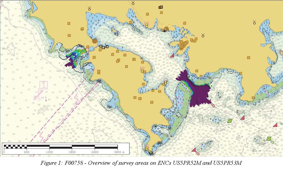
F00758: NOS Hydrographic Survey , 2018-10-30
National Oceanic and Atmospheric Administration, Department of Commerce —
The National Oceanic and Atmospheric Administration (NOAA) has the statutory mandate to collect hydrographic data in support of nautical chart compilation for safe... -
Federal
Shorelines for Vieques, Culebra, and the main island of Puerto Rico from the 1900s to 2018 (ver. 2.0, March 2023)
Department of the Interior —
The U.S. Geological Survey (USGS) maintains shoreline positions for the United States coasts from both older sources, such as aerial photographs or topographic... -
Federal
TIGER/Line Shapefile, 2022, County, Culebra Municipio, PR, Address Ranges Relationship File
U.S. Census Bureau, Department of Commerce —
The TIGER/Line shapefiles and related database files (.dbf) are an extract of selected geographic and cartographic information from the U.S. Census Bureau's Master... -
Federal
TIGER/Line Shapefile, Current, County, Culebra Municipio, PR, All Roads
U.S. Census Bureau, Department of Commerce —
This resource is a member of a series. The TIGER/Line shapefiles and related database files (.dbf) are an extract of selected geographic and cartographic information... -
Federal
TIGER/Line Shapefile, 2022, County, Culebra Municipio, PR, Topological Faces (Polygons With All Geocodes)
U.S. Census Bureau, Department of Commerce —
The TIGER/Line shapefiles and related database files (.dbf) are an extract of selected geographic and cartographic information from the U.S. Census Bureau's Master... -
Federal
NCCOS spatial modeling of threatened Caribbean corals: presence-only modeling for threatened Orbicella species from the nearshore to the mesophotic from 2007-01-01 to 2018-12-31 (NCEI Accession 0241110)
National Oceanic and Atmospheric Administration, Department of Commerce —
This dataset is a compilation of modeled spatial distributions of Threatened corals, Orbicella annularis (lobed star coral) and Orbicella faveolata (mountainous star... -
Federal
NEPR Accuracy Assessment Points - 2015
National Oceanic and Atmospheric Administration, Department of Commerce —
This shapefile denotes the ___location of underwater photos and videos taken in shallow water (0-35m) benthic habitats surrounding Northeast Puerto Rico and Culebra... -
Federal
2016 USACE Mean High Water Shorelines of the Puerto Rico coast used in Shoreline Change Analysis
Department of the Interior —
The U.S. Geological Survey (USGS) maintains shoreline positions for the United States coasts from both older sources, such as aerial photos or topographic surveys, as... -
Federal
TIGER/Line Shapefile, 2022, County, Culebra Municipio, PR, All Lines
U.S. Census Bureau, Department of Commerce —
The TIGER/Line shapefiles and related database files (.dbf) are an extract of selected geographic and cartographic information from the U.S. Census Bureau's Master... -
Federal
24-bit True Color SW Quadrant of RINCON NE, Orthophoto Production for Puerto Rico and US Virgin Island (rincon4_2004.tif)
Department of the Interior —
This dataset is a single orthoimage from a collection of GeoTIFF format natural color orthoimages covering the islands of Puerto Rico, Mona, Desecheo, Culebra,... -
Federal
Historic Inventory of Acropora Around Puerto Rico and U.S. Virgin Islands
National Oceanic and Atmospheric Administration, Department of Commerce —
Atlantic acroporid corals were listed as threatened under the Endangered Species Act (ESA) of 1973 on May 9, 2006, and a 4(d) rule was final on October 29, 2008,... -
Federal
NCCOS Assessment: Underwater Video for Ground Validation and Accuracy Assessment of Benthic Habitat Maps of the Insular Shelf South of St. Thomas and St. John, U.S. Virgin Islands, 2010-03-20 to 2017-02-10
National Oceanic and Atmospheric Administration, Department of Commerce —
The presence and absence of the four substrate and four biological cover types were documented at 1,353 locations on the insular shelf south of St. Thomas and St.... -
Federal
24-bit True Color NE Quadrant of RINCON NE, Orthophoto Production for Puerto Rico and US Virgin Islands (rincon1_2004.tif)
Department of the Interior —
This dataset is a single orthoimage from a collection of GeoTIFF format natural color orthoimages covering the islands of Puerto Rico, Mona, Desecheo, Culebra,... -
Federal
Shoreline change rates for the islands of Vieques and Culebra, Puerto Rico, calculated using the Digital Shoreline Analysis System version 5.1
Department of the Interior —
The U.S. Geological Survey (USGS) maintains shoreline positions for the United States coasts from both older sources, such as aerial photographs or topographic... -
Federal
Delineated Coastal Cliff Toes Derived from Post-Hurricane Maria Lidar Elevation Data Collected from Puerto Rico: 2018
Department of the Interior —
The National Assessment of Coastal Change Hazards project aims to understand and forecast coastal landscape change. This dataset consists of delineated coastal cliff...

Official websites use .gov
A
.gov website belongs to an official government
organization in the United States.
Secure .gov websites use HTTPS
A
lock (
) or https:// means you’ve safely connected to
the .gov website. Share sensitive information only on official,
secure websites.