
-
Federal
Sea level measured by tide gauges from global oceans as part of the Joint Archive for Sea Level (JASL) since 1846
National Oceanic and Atmospheric Administration, Department of Commerce —
This collection contains the complete holdings of the Joint Archive for Sea Level (JASL) for hourly and daily data that have been quality controlled, assessed, and... -
Federal
Basin Characteristics Data for the StreamStats Application in the Mystic River Basin, Massachusetts
Department of the Interior —
The U.S. Geological Survey’s StreamStats program is a publicly-accessible web application (https://streamstats.usgs.gov) that can be used to delineate drainage areas,... -
Federal
The database for the isopach map of the Brightseat Formation and structure contour map of the Cretaceous-Paleogene boundary, in Maryland and Virginia
Department of the Interior —
The goal of the Atlantic Subsurface Stratigraphic Initiative (ASSI) is to create isopach and structural contour maps for all Coastal Plain formations within the... -
Federal
F00548: NOS Hydrographic Survey , Wilmington, North Carolina, 2007-12-12
National Oceanic and Atmospheric Administration, Department of Commerce —
The National Oceanic and Atmospheric Administration (NOAA) has the statutory mandate to collect hydrographic data in support of nautical chart compilation for safe... -
City
Tsunami Evacuation Signs
City of Los Angeles —
LAPD & LAPP Tsunami evacuation map. Location of Tsunami evacuation signs posted throughout the Port, San Pedro and Wilmington area. Data will be refresh if... -
Federal
Soil and Water Assessment Tool (SWAT) models for the Cape Fear River Basin used to simulate future streamflow and irrigation demand based on climate and urban growth projections
Department of the Interior —
As part of the Coastal Carolinas Focus Area Study of the U.S. Geological Survey National Water Census Program, the Soil and Water Assessment Tool (SWAT) was used to... -
Federal
MODFLOW-6 model to update and extend the Los Angeles Coastal Plain Groundwater Model
Department of the Interior —
The Los Angeles Coastal Plain (LACP) covers about 580 square miles and is the largest coastal plain of semiarid southern California. The LACP is heavily developed... -
City
Tsunami Evacuation Routes
City of Los Angeles —
LAPD & LAPP Tsunami evacuation map. Location of Tsunami evacuation signs posted throughout the Port, San Pedro and Wilmington area. Data will be refresh if... -
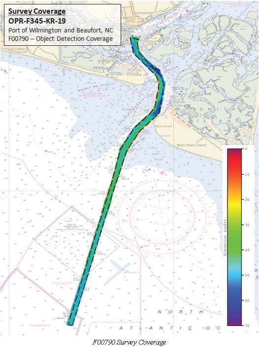
Federal
F00790: NOS Hydrographic Survey , 2019-09-08
National Oceanic and Atmospheric Administration, Department of Commerce —
The National Oceanic and Atmospheric Administration (NOAA) has the statutory mandate to collect hydrographic data in support of nautical chart compilation for safe... -
Federal
H05574: NOS Hydrographic Survey , 1934-01-01
National Oceanic and Atmospheric Administration, Department of Commerce —
The National Oceanic and Atmospheric Administration (NOAA) has the statutory mandate to collect hydrographic data in support of nautical chart compilation for safe... -
Federal
Autonomous Underwater Vehicle Water-Quality and Sonar Measurements in Delaware River near Philadelphia, Pennsylvania, 2019
Department of the Interior —
These data sets were created in support of the U.S. Geological Survey's (USGS) Next Generation Water Observing System (NGWOS) for the Delaware River Basin pilot study... -
Federal
Shoreline Data Rescue Project of Wilmington, Delaware, EC8B02 NGDA
National Oceanic and Atmospheric Administration, Department of Commerce —
These data were automated to provide an accurate high-resolution historical shoreline of Wilmington, Delaware suitable as a geographic information system (GIS) data... -
Federal
Digital Elevation Model and Derivative Datasets to Support the Integration of Stormwater Drainage into the StreamStats Application for the Mystic River Watershed, Massachusetts
Department of the Interior —
The U.S. Geological Survey’s StreamStats program is a publicly-accessible web application (https://streamstats.usgs.gov) that can be used to delineate drainage areas,... -
Federal
Pumping, Injection, and Water Spreading Model Input for the Los Angeles Coastal Plain Groundwater Model - MF6
Department of the Interior —
These data include pumping, injection, and water spreading input data for the MODFLOW-6 extension and update to Los Angeles Coastal Plain Groundwater Model (LACPGM-... -
Federal
MODFLOW-USG model used to evaluate water management issues in the Los Angeles Coastal Plain, California
Department of the Interior —
The U.S. Geological Survey (USGS), in cooperation with the Water Replenishment District of Southern California, developed a regional groundwater model of the Los... -
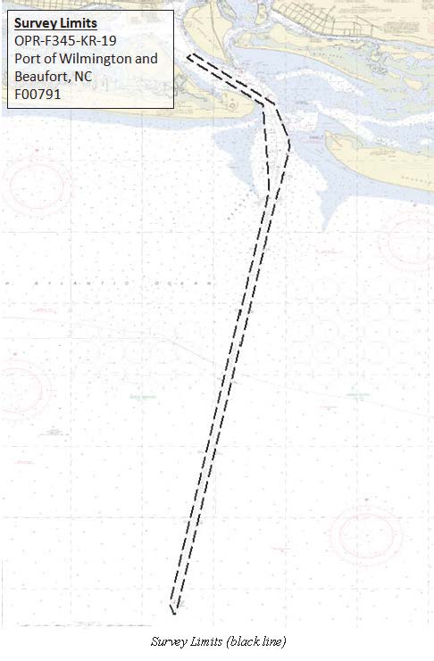
Federal
F00791: NOS Hydrographic Survey , 2019-09-09
National Oceanic and Atmospheric Administration, Department of Commerce —
The National Oceanic and Atmospheric Administration (NOAA) has the statutory mandate to collect hydrographic data in support of nautical chart compilation for safe... -
Federal
H11761: NOS Hydrographic Survey , Wilmington, North Carolina, 2007-12-12
National Oceanic and Atmospheric Administration, Department of Commerce —
The National Oceanic and Atmospheric Administration (NOAA) has the statutory mandate to collect hydrographic data in support of nautical chart compilation for safe... -
Federal
H11762: NOS Hydrographic Survey , Wilmington, North Carolina, 2007-12-11
National Oceanic and Atmospheric Administration, Department of Commerce —
The National Oceanic and Atmospheric Administration (NOAA) has the statutory mandate to collect hydrographic data in support of nautical chart compilation for safe... -
Federal
D00255: NOS Hydrographic Survey , 2018-09-20
National Oceanic and Atmospheric Administration, Department of Commerce —
The National Oceanic and Atmospheric Administration (NOAA) has the statutory mandate to collect hydrographic data in support of nautical chart compilation for safe...

Official websites use .gov
A
.gov website belongs to an official government
organization in the United States.
Secure .gov websites use HTTPS
A
lock (
) or https:// means you’ve safely connected to
the .gov website. Share sensitive information only on official,
secure websites.
.jpg)
.jpg)
.jpg)