
-
Federal
Global Volcano Hazard Frequency and Distribution
National Aeronautics and Space Administration —
Global Volcano Hazard Frequency and Distribution is a 2.5 minute gridded data set based upon the National Geophysical Data Center (NGDC) Volcano Database spanning the... -
Federal
Global Population Count Grid Time Series Estimates
National Aeronautics and Space Administration —
The Global Population Count Grid Time Series Estimates provide a back-cast time series of population grids based on the year 2000 population grid from SEDAC's Global... -
Federal
Population Exposure Estimates in Proximity to Nuclear Power Plants, Locations
National Aeronautics and Space Administration —
The Population Exposure Estimates in Proximity to Nuclear Power Plants, Locations data set combines information from a global data set developed by Declan Butler of... -
Federal
Low Elevation Coastal Zone (LECZ) Urban-Rural Population and Land Area Estimates, Version 2
National Aeronautics and Space Administration —
The Low Elevation Coastal Zone (LECZ) Urban-Rural Population and Land Area Estimates, Version 2 data set consists of country-level estimates of urban population,... -
Federal
FERMIGBRST - Fermi GBM Burst Catalog
National Aeronautics and Space Administration —
This table lists all of the triggers observed by a subset of the 14 GBM detectors (12 NaI and 2 BGO) which have been classified as gamma-ray bursts (GRBs). Note that... -
Federal
HANPP Collection: Global Patterns in Human Appropriation of Net Primary Productivity (HANPP)
National Aeronautics and Space Administration —
The HANPP Collection: Global Patterns in Human Appropriation of Net Primary Productivity (HANPP) represents a digital map of human appropriation of net primary... -
Federal
Goddard Earth Sciences Data and Information Services Center (GES DISC)
National Aeronautics and Space Administration —
The NASA Goddard Earth Sciences (GES) Data and Information Services Center (DISC) is the home (archive) of Precipitation, Atmospheric Chemistry and Dynamics, and... -
Federal
Low Elevation Coastal Zone (LECZ) Global Delta Urban-Rural Population and Land Area Estimates, Version 1
National Aeronautics and Space Administration —
The Low Elevation Coastal Zone (LECZ) Global Delta Urban-Rural Population and Land Area Estimates, Version 1 data set provides country-level estimates of urban,... -
Federal
Georeferenced Population Datasets of Mexico (GEO-MEX): Urban Place GIS Coverage of Mexico
National Aeronautics and Space Administration —
The Urban Place GIS Coverage of Mexico is a vector based point Geographic Information System (GIS) coverage of 696 urban places in Mexico. Each Urban Place is... -
Federal
Declassified Satellite Imagery 2 (2002)
National Aeronautics and Space Administration —
Declassified satellite images provide an important worldwide record of land-surface change. With the success of the first release of classified satellite photography... -
Federal
Global Rural-Urban Mapping Project, Version 1 (GRUMPv1): Urban Extents Grid
National Aeronautics and Space Administration —
The Global Rural-Urban Mapping Project, Version 1 (GRUMPv1): Urban Extents Grid distinguishes urban and rural areas based on a combination of population counts... -
Federal
Global Urban Heat Island (UHI) Data Set, 2013
National Aeronautics and Space Administration —
The Urban Heat Island (UHI) effect represents the relatively higher temperatures found in urban areas compared to surrounding rural areas owing to higher proportions... -
Federal
Global Monthly and Seasonal Urban and Land Backscatter Time Series, 1993-2020
National Aeronautics and Space Administration —
The Global Monthly and Seasonal Urban and Land Backscatter Time Series, 1993-2020, is a multi-sensor, multi-decadal, data set of global microwave backscatter, for... -
Federal
SMAP-Derived 1-km Downscaled Surface Soil Moisture Product V001
National Aeronautics and Space Administration —
This data product contains global daily 1 km resolution surface soil moisture derived from the SMAP L-band radiometer. Specifically, MODIS land surface temperature... -
Federal
My NASA Data
National Aeronautics and Space Administration —
MY NASA DATA (MND) is a tool that allows anyone to make use of satellite data that was previously unavailable.Through the use of MND’s Live Access Server (LAS) a... -
Federal
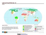
Last of the Wild Project, Version 2, 2005 (LWP-2): Last of the Wild Dataset (Geographic)
National Aeronautics and Space Administration —
The Last of the Wild Dataset of the Last of the Wild Project, Version 2, 2005 (LWP-2) is derived from the LWP-2 Human Footprint Dataset. The gridded data are... -
Federal
Last of the Wild Project, Version 2, 2005 (LWP-2): Global Human Influence Index (HII) Dataset (Geographic)
National Aeronautics and Space Administration —
The Global Human Influence Index Dataset of the Last of the Wild Project, Version 2, 2005 (LWP-2) is a global dataset of 1-kilometer grid cells, created from nine... -
Federal
OMNIWeb at the Space Physics Data Facility (SPDF)
National Aeronautics and Space Administration —
Hourly-averaged near-Earth solar wind magnetic field and plasma, etc. The web services consists of OMNI data (spacecraft-interspersed, near-Earth solar wind data);...

Official websites use .gov
A
.gov website belongs to an official government
organization in the United States.
Secure .gov websites use HTTPS
A
lock (
) or https:// means you’ve safely connected to
the .gov website. Share sensitive information only on official,
secure websites.