Spindrift Col is a mountain pass running through north-central Signy Island in the South Orkney Islands. It is located 0.5 nautical miles (0.9 km) southeast of Spindrift Rocks, its namesake.
 Signy Island base and panorama | |
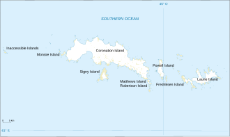
 Map of the South Orkney Islands | |
| Geography | |
|---|---|
| Coordinates | 60°36′S 45°30′W / 60.600°S 45.500°W |
| Area | 620 km2 (240 sq mi) |
| Highest elevation | 4,153 ft (1265.8 m) |
| Administration | |
Administered under the Antarctic Treaty System | |
| Demographics | |
| Population | approx. 53-55 (summer) 14 (winter) |
It was named by the United Kingdom Antarctic Place-Names Committee (UK-APC) in 1974, after the sea spray that occurs in their surroundings with strong westerly winds.
References
edit- "Antarctica Detail". USGS. Archived from the original on 2 June 2021. Retrieved 10 April 2025.
- "Spindrift Col". geographic.org. Retrieved 10 April 2025.
This article incorporates public ___domain material from "Spindrift Col". Geographic Names Information System. United States Geological Survey.