Wikipedia:WikiProject Maps/Conventions/Orthographic maps
This page provides conventions for the creation of orthographic maps. Orthographic maps display a country (or set of countries) on a globe representation of the world. Like ___location maps, orthographic maps are very basic, and should have very few, if any, labels. Maps should be centred on the subject of interest.
Usage: These maps are often used in country infoboxes Template:Infobox Country to demonstrate where a country is in the world.
Where: These maps can be found on Wikimedia Commons, Grey-green orthographic projections maps.
Tutorial: here (perl) or here (French)
Generative tool: Online on ObservableHQ, on the left of the map, click « ⋮ » then « Download SVG »:
Convention
edit| Subject | Colorimetry (RGB/hex) |
|---|---|
| Subject's area (country, province, state, etc.) | #346733
R:52 G:103 B:51 A:1 |
| Subject border | #335033
R:51 G:80 B:51 A:1 |
| Other areas part of the same political unity | #C6DEBD
R:198 G:222 B:189 A:1 |
| Claimed uncontrolled areas | #49C946
R:73 G:201 B:70 A:1 |
| Outside area | #B9B9B9
R:185 G:185 B:185 A:1 |
| Other borders | #FFFFFF
R:255 G:255 B:255 A:1 |
| Water (ocean, sea, lake, etc.) | #FFFFFF
R:255 G:255 B:255 A:1 |
| Border of the globe | #AAAAAA
R:170 G:170 B:170 A:1 |
| Latitude/longitude grid | #000000C4
R:0 G:0 B:0 A:0.77 |
|
Naming (upload):
| |
|
Other specifications: | |
Motivations
editTo identify where a country is with respect to other nearby countries that the viewer may know about.
History and current work
editThe first of these maps was uploaded to Wikimedia Commons by User:Ssolbergj in 2008.
These conventions are from Commons:Grey-green orthographic projections maps, although maps are not [yet] consistent in presentation style. Discuss proposed improvements.
- The surrounding area colours were taken from Commons:Template:EU-SVG-en.
- The gradient, border of the globe, and the colours of the latitude/longitude grid were based on original files created by User:Ssolbergj.
- Perlshaper tutorial (French)
Examples
editTwo different orthographic color schemes have widespread usages within Wikipedias and Wikimedia websites.
-
 Australia
 -
 Democratic Republic of the Congo
 -
 China
China -
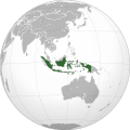 Indonesia
 -
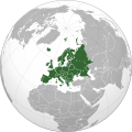 Europe
.svg)
.svg)
.svg)
.svg)
.svg)
-
 Australia
 -
 Democratic Republic of the Congo
 -
 China
China -
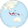 Indonesia
 -
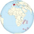 France and dependent oversea areas
.svg)
.svg)
.svg)
.svg)
_(Africa_centered).svg)
See also
editMap conventions and Map Project | |||
|---|---|---|---|
 | Conventions set |  | |
| Drafts | |||
| Others |
| ||